
Panaji topographic map
Interactive map
Click on the map to display elevation.
Panaji
Panaji was annexed by India with the rest of Goa and the former Portuguese territories after the Indian annexation of Portuguese India in 1961. It became a state-capital on Goa's elevation to statehood in 1987. Between 1961 and 1987, it was the capital of the Union Territory of Goa, Daman and Diu. A new Legislative Assembly complex was inaugurated in March 2000, across the Mandovi River, in Alto Porvorim. Panaji is also the administrative headquarters of North Goa district.
About this map
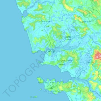
Name: Panaji topographic map, elevation, terrain.
Location: Panaji, Tiswadi, North Goa, Goa, 403001, India (15.33899 73.66821 15.65899 73.98821)
Average elevation: 19 m
Minimum elevation: -3 m
Maximum elevation: 285 m
Other topographic maps
Click on a map to view its topography, its elevation and its terrain.