
Aburi topographic map
Interactive map
Click on the map to display elevation.
About this map
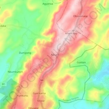
Name: Aburi topographic map, elevation, terrain.
Location: Aburi, Akuapim South District, Eastern Region, Ghana (5.80748 -0.21527 5.88748 -0.13527)
Average elevation: 277 m
Minimum elevation: 88 m
Maximum elevation: 478 m
Due to the altitude of Aburi, the climate is a lot cooler than neighbouring Accra. The road which climbs the hillside to Aburi is a toll road, with the current toll being 0.50 Ghc for a car, 1.00 Ghc for a 4x4.
Other topographic maps
Click on a map to view its topography, its elevation and its terrain.
Berekuso
Ghana > Eastern Region > Akuapim South District
Berekuso, Akuapim South District, Eastern Region, Ghana
Average elevation: 225 m