
Loudervielle topographic map
Interactive map
Click on the map to display elevation.
About this map
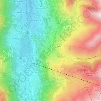
Name: Loudervielle topographic map, elevation, terrain.
Average elevation: 1,244 m
Minimum elevation: 922 m
Maximum elevation: 1,737 m
Other topographic maps
Click on a map to view its topography, its elevation and its terrain.
Col de Peyresourde
France > Occitania > Loudervielle
Col de Peyresourde, D 618, Loudervielle, Bagnères-de-Bigorre, Hautespyrenees, Occitania, Metropolitan France, 65240, France
Average elevation: 1,615 m