
Errol topographic map
Interactive map
Click on the map to display elevation.
About this map
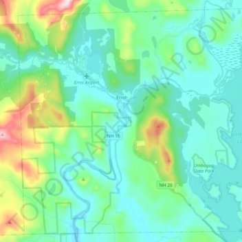
Name: Errol topographic map, elevation, terrain.
Location: Errol, Coös County, New Hampshire, United States (44.70826 -71.21592 44.82853 -71.03441)
Average elevation: 453 m
Minimum elevation: 358 m
Maximum elevation: 820 m
According to the United States Census Bureau, the town has a total area of 69.5 square miles (179.9 km2), of which 60.3 square miles (156.3 km2) are land and 9.1 square miles (23.5 km2) are water, comprising 13.09% of the town. The Androscoggin River begins in Errol, where the Magalloway River joins the outlet of Umbagog Lake. The town's elevation reaches 2,350 feet (720 m) above sea level atop a bump above Signal Pond near the town's western boundary. Errol lies fully within the Androscoggin River watershed.
Other topographic maps
Click on a map to view its topography, its elevation and its terrain.
Mount Washington
United States > New Hampshire > Coos County
Mount Washington, Coös County, New Hampshire, United States
Average elevation: 1,568 m
Millsfield
United States > New Hampshire > Coos County
Millsfield, Coös County, New Hampshire, United States
Average elevation: 583 m
Jefferson Highland
United States > New Hampshire > Coos County > Jefferson
Jefferson Highland, Jefferson, Coös County, New Hampshire, 03583, United States
Average elevation: 451 m
Jefferson
United States > New Hampshire > Coos County
Jefferson, Coös County, New Hampshire, 03583, United States
Average elevation: 493 m
Blake Islands
United States > New Hampshire > Coos County > Errol
Blake Islands, Errol, Coös County, New Hampshire, United States
Average elevation: 530 m
Pittsburg
United States > New Hampshire > Coos County
Pittsburg, Coös County, New Hampshire, United States
Average elevation: 522 m
Dummer
United States > New Hampshire > Coos County
Dummer, Coos County, New Hampshire, United States
Average elevation: 419 m
Glen House
United States > New Hampshire > Coos County
Glen House, Green's Grant, Coos County, New Hampshire, United States
Average elevation: 647 m
Fabyan
United States > New Hampshire > Coos County > Carroll
Fabyan, Carroll, Coos County, New Hampshire, 03575, United States
Average elevation: 590 m
Lake Francis
United States > New Hampshire > Coos County > Clarksville
Lake Francis, Clarksville, Coos County, New Hampshire, United States
Average elevation: 498 m
Bretton Woods
United States > New Hampshire > Coos County > Carroll
Bretton Woods, Carroll, Coös County, New Hampshire, 03575, United States
Average elevation: 577 m
Mount Pisgah
United States > New Hampshire > Coos County > Clarksville
Mount Pisgah, Clarksville, Coos County, New Hampshire, United States
Average elevation: 735 m
Sugar Mountain
United States > New Hampshire > Coos County > Gorham
Sugar Mountain, Gorham, Coos County, New Hampshire, United States
Average elevation: 607 m
Gorham
United States > New Hampshire > Coos County
Gorham, Coös County, New Hampshire, 03581, United States
Average elevation: 477 m
Whitefield
United States > New Hampshire > Coos County
Whitefield, Coös County, New Hampshire, United States
Average elevation: 365 m
Stewartstown
United States > New Hampshire > Coos County
Stewartstown, Coös County, New Hampshire, 03597, United States
Average elevation: 485 m