
Kampung Kebun Teh topographic map
Interactive map
Click on the map to display elevation.
About this map
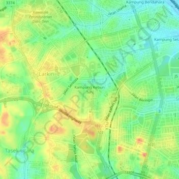
Name: Kampung Kebun Teh topographic map, elevation, terrain.
Location: Kampung Kebun Teh, Johor Bahru, Johor, 80250, Malaysia (1.47236 103.73079 1.51236 103.77079)
Average elevation: 29 m
Minimum elevation: 4 m
Maximum elevation: 60 m
Other topographic maps
Click on a map to view its topography, its elevation and its terrain.
Pandan Lake Recreation Site
Malaysia > Johor > Johor Bahru > Kampung Seri Bahagia
Average elevation: 11 m