
Boaco topographic map
Interactive map
Click on the map to display elevation.
Boaco
Boaco is located in the hilly central region of Nicaragua. Its topography is irregular with many mountains, which are smaller than the mountains in northern Nicaragua. The highest peak is El Cerro de la Vieja (the old woman's hill) with an altitude of 1,020 m. The average elevation above sea level is 360 m.
About this map
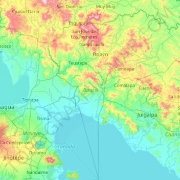
Name: Boaco topographic map, elevation, terrain.
Location: Boaco, Nicaragua (11.70960 -85.98710 12.80088 -84.95208)
Average elevation: 261 m
Minimum elevation: 29 m
Maximum elevation: 1,325 m
Other topographic maps
Click on a map to view its topography, its elevation and its terrain.
Volcán Masaya
In 1979, Masaya became Nicaragua's first national park, named Masaya Volcano National Park (Parque Nacional Volcán Masaya). The park has an area of 54 km2 (21 sq mi) and includes two volcanoes and five craters, as well as a range of elevations between 100 and 630 meters above sea level. In the park is a lava…
Average elevation: 449 m
Managua
Nicaragua > Departamento de Managua > Managua
Managua, due to its tropical climate, varied topography, naturally fertile soils, and abundant rain and water sources, boasts a great variety of flora. Many different types of trees, some of which are not found elsewhere in the world, appear, including chilamates, ceibos, pochotes, genízaros, tigüilotes,…
Average elevation: 194 m
Páhara
Nicaragua > North Carribean Coast Autonomous Region > Puerto Cabezas (Municipio) > Páhara
Average elevation: 5 m