
Vrindavan topographic map
Interactive map
Click on the map to display elevation.
Vrindavan
Vrindavan is located at 27°35′N 77°42′E / 27.58°N 77.7°E / 27.58; 77.7. It has an average elevation of 170 metres (557 feet).
About this map
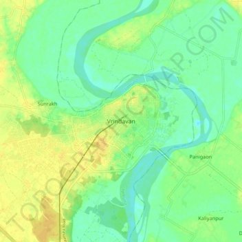
Name: Vrindavan topographic map, elevation, terrain.
Location: Vrindavan, Mathura, Uttar Pradesh, 281121, India (27.53537 77.65380 27.61537 77.73380)
Average elevation: 172 m
Minimum elevation: 161 m
Maximum elevation: 184 m
Other topographic maps
Click on a map to view its topography, its elevation and its terrain.