
Cachoeira Bom jardim topographic map
Interactive map
Click on the map to display elevation.
About this map
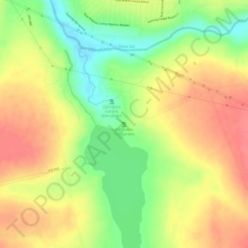
Name: Cachoeira Bom jardim topographic map, elevation, terrain.
Average elevation: 825 m
Minimum elevation: 783 m
Maximum elevation: 854 m
Other topographic maps
Click on a map to view its topography, its elevation and its terrain.
Alto Umuarama
Brazil > Minas Gerais > Uberlândia
Alto Umuarama, Setor Leste, Uberlândia, Região Geográfica Imediata de Uberlândia, Região Geográfica Intermediária de Uberlândia, Minas Gerais, Southeast Region, Brazil
Average elevation: 913 m
Uberlândia
Brazil > Minas Gerais > Uberlândia
Uberlândia, Região Geográfica Imediata de Uberlândia, Região Geográfica Intermediária de Uberlândia, Minas Gerais, Southeast Region, 38.400-130, Brazil
Average elevation: 831 m
Guarani
Brazil > Minas Gerais > Uberlândia
Guarani, Setor Oeste, Uberlândia, Microrregião Uberlândia, Mesorregião Triângulo Mineiro/Alto Paranaiba, Minas Gerais, Southeast Region, Brazil
Average elevation: 806 m
São Jorge
Brazil > Minas Gerais > Uberlândia
São Jorge, Setor Sul, Uberlândia, Microrregião Uberlândia, Mesorregião Triângulo Mineiro/Alto Paranaiba, Minas Gerais, Southeast Region, 38410420, Brazil
Average elevation: 900 m