
Al Machouar Stinia ⵍⵎⵛⵡⵕ ⵙⵜⵜⵉⵏⵢⵢⴰ المشور الستينية topographic map
Interactive map
Click on the map to display elevation.
About this map
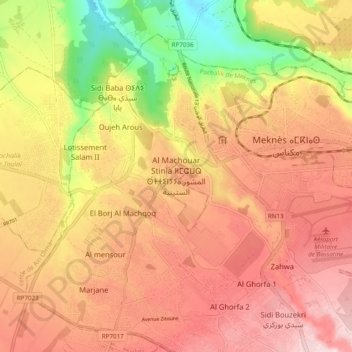
Name: Al Machouar Stinia ⵍⵎⵛⵡⵕ ⵙⵜⵜⵉⵏⵢⵢⴰ المشور الستينية topographic map, elevation, terrain.
Average elevation: 503 m
Minimum elevation: 330 m
Maximum elevation: 619 m