
Salyan topographic map
Interactive map
Click on the map to display elevation.
About this map
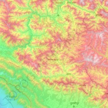
Name: Salyan topographic map, elevation, terrain.
Location: Salyan, Karnali Province, 22202, Nepal (28.16946 81.74337 28.64519 82.43719)
Average elevation: 1,238 m
Minimum elevation: 168 m
Maximum elevation: 2,789 m
From 1992 to 2002 a definitive series of large scale topographic maps were surveyed and published through a joint project by Government of Nepal Survey Department and Finland's Ministry for Foreign Affairs contracting through the FinnMap consulting firm. Japan International Cooperation Agency substituted for FinnMap in Lumbini Zone. Topographic sheets at 1:25,000 scale covering 7.5 minutes latitude and longitude map the Terai and Middle Mountains. Less populated high mountain regions are on 15 minute sheets at 1:50,000. JPG scans can be downloaded here: These sheets cover Salyan District:
Other topographic maps
Click on a map to view its topography, its elevation and its terrain.
Haredanda
Nepal > Karnali Province > Surkhet > Birendranagar
Haredanda, Birendranagar-15, Birendranagar, Surkhet, Karnali Province, Nepal
Average elevation: 1,294 m
Dungeshwor
Nepal > Karnali Province > Dailekh
Dungeshwor, Dailekh, Karnali Province, Nepal
Average elevation: 1,313 m
Thini
Nepal > Karnali Province > Mugu
Thini, Chhayanath Rara, Mugu, Karnali Province, Nepal
Average elevation: 2,192 m
Patmara
Nepal > Karnali Province > Jumla
Patmara, Patrasi, Jumla, Karnali Province, Nepal
Average elevation: 3,358 m
Chandannath
Nepal > Karnali Province > Jumla
Chandannath, Jumla, Karnali Province, Nepal
Average elevation: 3,053 m
Patrasi
Nepal > Karnali Province > Jumla
Patrasi, Jumla, Karnali Province, Nepal
Average elevation: 3,877 m
Dillichaur
Nepal > Karnali Province > Jumla
Dillichaur, Patrasi, Jumla, Karnali Province, Nepal
Average elevation: 2,864 m
Barekot
Nepal > Karnali Province > Jajarkot
Barekot, Jajarkot, Karnali Province, Nepal
Average elevation: 3,096 m
Western Rukum District
Western Rukum District, Karnali Province, 22000, Nepal
Average elevation: 2,181 m
Shey Phoksundo National Park
Shey Phoksundo National Park, Karnali Province, Nepal
Average elevation: 4,568 m