
Dang topographic map
Interactive map
Click on the map to display elevation.
About this map
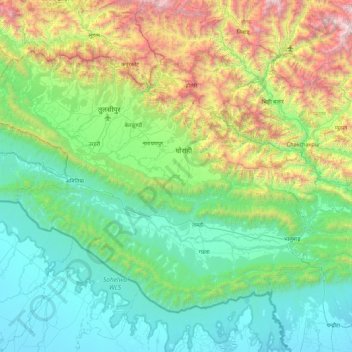
Name: Dang topographic map, elevation, terrain.
Location: Dang, Lumbini Province, Nepal (27.67644 81.92083 28.28303 82.81032)
Average elevation: 746 m
Minimum elevation: 109 m
Maximum elevation: 2,914 m
The Dudhwas rise steeply to a crest at about 700 meters, then slope more gradually into the Deukhuri Valley, down to 250 meters elevation at the Rapti River. The Dudhwas extend more than 100 km, causing the Rapti to detour west around them before turning southeast down the main trend of the plains into India. Deukhuri's climate is nearly tropical and it is well watered by the river, as well as possessing abundant groundwater. North of Deukhuri Valley, the Dang Range rises as high as 1,000 meters with passes at about 700 meters. The Dang Valley lies north of these hills, drained by the Babai River tributary to the Ghaghara (Karnali). Valley elevations range from 600 meters along the Babai with alluvial slopes gradually rising northward to 700 meters along the base of the Mahabharat Range. The district then extends upslope to the crest of the Mahabharats at 1,500 to 1,700 meters elevation. The bordering districts to the north are Pyuthan, Rolpa, and Salyan. The Rapti River of Western Nepal traverses through most of the lower Dang valley. It flows beneath the Churia range first on the northern side of the hills and then leaves the hills on the southern side. Nepal's second-longest bridge over Rapti river in Dang district connects Sisahaniya of Rapti Rural Municipality with Mahadeva of Gadawa Rural Municipality in the district.
Other topographic maps
Click on a map to view its topography, its elevation and its terrain.
Nawalparasi West / Bardaghat Susta
Nepal > Lumbini Province > Nawalparasi W
Nawalparasi West / Bardaghat Susta, Nawalparasi W, Lumbini Province, Nepal
Average elevation: 263 m
Arghakhanchi
Arghakhanchi, Lumbini Province, 32700, Nepal
Average elevation: 962 m
Kapilbastu
Nepal > Lumbini Province > Kapilvastu
Kapilbastu, Kapilvastu, Lumbini Province, Nepal
Average elevation: 105 m
Tilottama
Nepal > Lumbini Province > Rupandehi
Tilottama, Rupandehi, Lumbini Province, 32903, Nepal
Average elevation: 130 m
Hyang
Nepal > Lumbini Province > Rolpa
Hyang, Triveni-02, Tribeni, Rolpa, Lumbini Province, Nepal
Average elevation: 1,462 m
Bhaba
Nepal > Lumbini Province > Rolpa
Bhaba, Sunchhahari-03, Sunchhahari, Rolpa, Lumbini Province, Nepal
Average elevation: 2,423 m
Satyawati
Nepal > Lumbini Province > Gulmi
Satyawati, Gulmi, Lumbini Province, Nepal
Average elevation: 1,261 m
Putha Uttarganga
Nepal > Lumbini Province > Eastern Rukum
Putha Uttarganga, Eastern Rukum, Lumbini Province, Nepal
Average elevation: 2,899 m
Bagnaskali
Nepal > Lumbini Province > Palpa
Bagnaskali, Palpa, Lumbini Province, 32500, Nepal
Average elevation: 862 m