
Kulgaon Badlapur topographic map
Interactive map
Click on the map to display elevation.
About this map
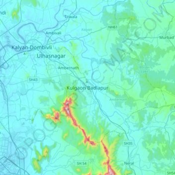
Name: Kulgaon Badlapur topographic map, elevation, terrain.
Location: Kulgaon Badlapur, Ambarnath, Thane, Maharashtra, 421503, India (19.00502 73.07753 19.32502 73.39753)
Average elevation: 65 m
Minimum elevation: -3 m
Maximum elevation: 797 m
Other topographic maps
Click on a map to view its topography, its elevation and its terrain.
Barvi
India > Maharashtra > Kulgaon Badlapur
Barvi, Kulgaon Badlapur, Ambarnath, Thane, Maharashtra, 421503, India
Average elevation: 63 m