
Bhander topographic map
Interactive map
Click on the map to display elevation.
About this map
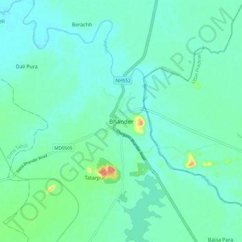
Name: Bhander topographic map, elevation, terrain.
Location: Bhander, Bhander Tahsil, Datia, Madhya Pradesh, India (25.69532 78.70513 25.77532 78.78513)
Average elevation: 181 m
Minimum elevation: 164 m
Maximum elevation: 256 m
Bhander is located at 25°44′N 78°45′E / 25.73°N 78.75°E / 25.73; 78.75. It has an average elevation of 211 metres (692 feet). Bhandar or Bhander is another village in Rajasthan in Pali district and in tehsil Bali.