
Vernon topographic map
Interactive map
Click on the map to display elevation.
About this map
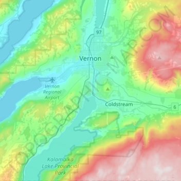
Name: Vernon topographic map, elevation, terrain.
Average elevation: 676 m
Minimum elevation: 338 m
Maximum elevation: 1,486 m
Other topographic maps
Click on a map to view its topography, its elevation and its terrain.
Coldstream
Canada > British Columbia > Regional District of North Okanagan
Coldstream, Regional District of North Okanagan, British Columbia, Canada
Average elevation: 772 m