
Make a donation
Gear up for your next adventure:
As an Amazon Associate, this site earns from qualifying purchases at no extra cost to you.
Općina Kamanje / Grad Ozalj topographic map
Click on the map to display elevation.
Make a donation
Gear up for your next adventure:
As an Amazon Associate, this site earns from qualifying purchases at no extra cost to you.
About this map
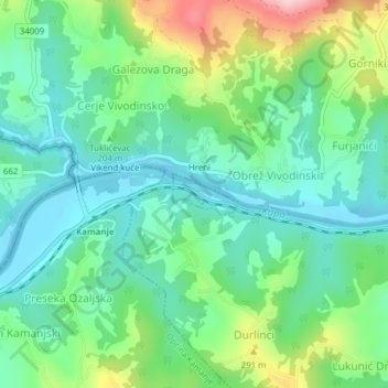
Name: Općina Kamanje / Grad Ozalj topographic map, elevation, terrain.
Location: Općina Kamanje / Grad Ozalj, Karlovac County, Croatia (45.64560 15.41619 45.64848 15.42265)
Average elevation: 196 m
Minimum elevation: 124 m
Maximum elevation: 372 m
Make a donation
Gear up for your next adventure:
As an Amazon Associate, this site earns from qualifying purchases at no extra cost to you.
Other topographic maps
Click on a map to view its topography, its elevation and its terrain.
Zagreb
Zagreb (/ˈzɑːɡrɛb, ˈzæɡrɛb, zɑːˈɡrɛb/ ZAH-greb, ZAG-reb, zah-GREB, Croatian: [zǎːɡreb] (listen)) is the capital and largest city of Croatia. It is in the northwest of the country, along the Sava river, at the southern slopes of the Medvednica mountain. Zagreb stands near the international…
Average elevation: 249 m
Make a donation
Gear up for your next adventure:
As an Amazon Associate, this site earns from qualifying purchases at no extra cost to you.
Make a donation
Gear up for your next adventure:
As an Amazon Associate, this site earns from qualifying purchases at no extra cost to you.
Make a donation
Gear up for your next adventure:
As an Amazon Associate, this site earns from qualifying purchases at no extra cost to you.
Grad Slatina
Croatia > Virovitica-Podravina County
Slatina is a town in the Slavonia region of Croatia. It is located in the Virovitica-Podravina County, at the contact of the Drava valley and the foothills of Papuk mountain, in the central part of the region of Podravina, 29 km (18 mi) southeast of Virovitica; elevation 127 metres (417 feet). It was ruled by…
Average elevation: 137 m
Make a donation
Gear up for your next adventure:
As an Amazon Associate, this site earns from qualifying purchases at no extra cost to you.
Krapanj
Croatia > Šibenik-Knin County > Grad Šibenik > Krapanj
Krapanj is one of the smallest inhabited islands of the Adriatic Sea covering 0.36 km2. It is the lowest island on the Adriatic with an elevation of 1.5m above sea level. Krapanj is 300m offshore at its closest point from the mainland town of Brodarica.
Average elevation: 5 m
Grad Rovinj
Since records began in 1984, the highest temperature recorded at the Sveti Ivan na pučini weather station at an elevation of 8 metres (26 ft) was 34.2 °C (93.6 °F), on 5 August 2017. The coldest temperature was −6.5 °C (20.3 °F), on 29 December 1996.
Average elevation: 24 m
Zadar
Since records began in 1961, the highest temperature recorded at the local weather station at an elevation of 5 metres (16 ft) was 36.3 °C (97.3 °F), on 4 August 2017. The coldest temperature was −9.1 °C (15.6 °F), on 23 January 1963.
Average elevation: 29 m
Make a donation
Gear up for your next adventure:
As an Amazon Associate, this site earns from qualifying purchases at no extra cost to you.
Make a donation
Gear up for your next adventure:
As an Amazon Associate, this site earns from qualifying purchases at no extra cost to you.
National park Paklenica
The central part of the Park is distinctive for the relief complex of Borovnik and Crni vrh, with the valley of Mala Močila and Velika Močila nearby. In terms of relief, Velika Močila is a very interesting bowl-shaped valley at an altitude 850 m asl, surrounded by Crni vrh (1 110 m asl), Škiljina kosa (1…
Average elevation: 853 m
Make a donation
Gear up for your next adventure:
As an Amazon Associate, this site earns from qualifying purchases at no extra cost to you.
Make a donation
Gear up for your next adventure:
As an Amazon Associate, this site earns from qualifying purchases at no extra cost to you.
Plitvice Lakes National Park
The area of Plitvice Lakes National Park extends across two political subdivisions or counties (Croatian županija). Its 296.85 km2 (114.61 sq mi) area is divided between Lika-Senj County (90.7 percent) and Karlovac County (9.3 percent), hence the national park authority is under national jurisdiction. The…
Average elevation: 765 m
Make a donation
Gear up for your next adventure:
As an Amazon Associate, this site earns from qualifying purchases at no extra cost to you.
Make a donation
Gear up for your next adventure:
As an Amazon Associate, this site earns from qualifying purchases at no extra cost to you.
Općina Suhopolje
Croatia > Virovitica-Podravina County
It is located on the northern slopes of the Bilogora mountain in the region of Podravina, 10 km southeast of Virovitica; elevation 118 m.
Average elevation: 151 m
Vukovar
Croatia > Vukovar-Srijem County
Vukovar is located 20 km (12 mi) northeast of Vinkovci and 36 km (22 mi) southeast of Osijek, with an elevation of 108 m (354 ft). Vukovar is located on the main road D2 Osijek—Vukovar—Ilok and on the Vinkovci—Vukovar railway (and road D55).
Average elevation: 94 m
Make a donation
Gear up for your next adventure:
As an Amazon Associate, this site earns from qualifying purchases at no extra cost to you.
Make a donation
Gear up for your next adventure:
As an Amazon Associate, this site earns from qualifying purchases at no extra cost to you.
Make a donation
Gear up for your next adventure:
As an Amazon Associate, this site earns from qualifying purchases at no extra cost to you.
Make a donation
Gear up for your next adventure:
As an Amazon Associate, this site earns from qualifying purchases at no extra cost to you.
Make a donation
Gear up for your next adventure:
As an Amazon Associate, this site earns from qualifying purchases at no extra cost to you.
Make a donation
Gear up for your next adventure:
As an Amazon Associate, this site earns from qualifying purchases at no extra cost to you.
Grad Križevci
Croatia > Koprivnica-Križevci County
Topographically, it lies on Pleistocene foundations, between swamped alluvial valleys of the brook Vrtlin from the east and the brook Koruska from the west. Relief, geological-petrografical structure, convenient climate and abundance of water, all contribute to the economic and demographic development of the…
Average elevation: 196 m
Make a donation
Gear up for your next adventure:
As an Amazon Associate, this site earns from qualifying purchases at no extra cost to you.
Općina Mrkopalj
Croatia > Primorje-Gorski Kotar County
A weather station exists there at an elevation of 825 metres (2,707 ft), although under a shelter that compromises the applicability to surroundings. The minimum recorded temperature for the winter of 2024–2025 was −16.2 °C (2.8 °F), on February 20.
Average elevation: 1,010 m
Make a donation
Gear up for your next adventure:
As an Amazon Associate, this site earns from qualifying purchases at no extra cost to you.
Grad Bjelovar
Croatia > Bjelovar-Bilogora County
Bjelovar sits on a plateau in the southern part of the Bilogora, a long, low elevation range with an average height of 150–200 m (highest point: Rajčevica, 309 m). The geology of the area consists of Pliocene sandy marl and sandstones with lesser layers of lignite. Older rocks do not appear on the surface…
Average elevation: 138 m
Make a donation
Gear up for your next adventure:
As an Amazon Associate, this site earns from qualifying purchases at no extra cost to you.
Đakovo
Croatia > Osijek-Baranja County
Đakovo is located 37 km (23 mi) to the southwest of Osijek and 34 km (21 mi) southeast of Našice; elevation 111 m. It is located near the A5 motorway, at the intersection of the D7 state road to Osijek, the arterial roads D38 to Požega, D46 to Vinkovci and the connecting road D515 to Našice.
Average elevation: 103 m
Make a donation
Gear up for your next adventure:
As an Amazon Associate, this site earns from qualifying purchases at no extra cost to you.
Begovo Razdolje
Croatia > Primorje-Gorski Kotar County
Begovo Razdolje (Croatian pronunciation: [bɛ̂ɡɔʋɔ rǎːzdɔːʎɛ]) is a village in Mrkopalj municipality, Primorje-Gorski Kotar County, in western Croatia. At 1,060 m (3,478 ft), it is the settlement with the highest elevation in Croatia.
Average elevation: 1,072 m
Make a donation
Gear up for your next adventure:
As an Amazon Associate, this site earns from qualifying purchases at no extra cost to you.
Jastrebarsko
Jastrebarsko is located in the Prigorje region of Central Croatia, built around the Reka Creek (Croatian: Potok Reka; reka is Kajkavian dialect word for river). On the west, Jastrebarsko is bordered by the Žumberak Mountain (Croatian: Žumberačka gora), a mountain range spreading through southeast Slovenia…
Average elevation: 145 m
Make a donation
Gear up for your next adventure:
As an Amazon Associate, this site earns from qualifying purchases at no extra cost to you.
Make a donation
Gear up for your next adventure:
As an Amazon Associate, this site earns from qualifying purchases at no extra cost to you.
Make a donation
Gear up for your next adventure:
As an Amazon Associate, this site earns from qualifying purchases at no extra cost to you.
Grad Bjelovar
Croatia > Bjelovar-Bilogora County
Bjelovar sits on a plateau in the southern part of the Bilogora, a long, low elevation range with an average height of 150–200 m (highest point: Rajčevica, 309 m). The geology of the area consists of Pliocene sandy marl and sandstones with lesser layers of lignite. Older rocks do not appear on the surface…
Average elevation: 138 m
Make a donation
Gear up for your next adventure:
As an Amazon Associate, this site earns from qualifying purchases at no extra cost to you.