
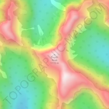
Depth Peak topographic map
Interactive map
Click on the map to display elevation.
About this map
Name: Depth Peak topographic map, elevation, terrain.
Average elevation: 680 m
Minimum elevation: 258 m
Maximum elevation: 1,169 m
Other topographic maps
Click on a map to view its topography, its elevation and its terrain.
Borland
New Zealand > Southland > Southland District > Fiordland Community
Borland, Fiordland Community, Southland District, Southland, New Zealand
Average elevation: 880 m
Fern Hill
New Zealand > Southland > Southland District > Fiordland Community
Fern Hill, Fiordland Community, Southland District, Southland, New Zealand
Average elevation: 259 m
Sutherland Falls
New Zealand > Southland > Southland District > Fiordland Community
Sutherland Falls, Fiordland Community, Southland District, Southland, New Zealand
Average elevation: 1,006 m
Mount Owen
New Zealand > Southland > Southland District > Fiordland Community
Mount Owen, Fiordland Community, Southland District, Southland, New Zealand
Average elevation: 1,269 m
Milford Sound
New Zealand > Southland > Southland District > Fiordland Community
Milford Sound, Fiordland Community, Southland District, Southland, New Zealand
Average elevation: 655 m
Turner Falls
New Zealand > Southland > Southland District > Fiordland Community
Turner Falls, Fiordland Community, Southland District, Southland, New Zealand
Average elevation: 1,335 m
352
New Zealand > Southland > Southland District > Fiordland Community
352, Fiordland Community, Southland District, Southland, New Zealand
Average elevation: 273 m
Mount Makere
New Zealand > Southland > Southland District > Fiordland Community
Mount Makere, Fiordland Community, Southland District, Southland, New Zealand
Average elevation: 1,433 m
Long Burn
New Zealand > Southland > Southland District > Fiordland Community
Long Burn, Fiordland Community, Southland District, Southland, New Zealand
Average elevation: 721 m
Jamestown
New Zealand > Southland > Southland District > Fiordland Community
Jamestown, Fiordland Community, Southland District, Southland, New Zealand
Average elevation: 43 m
Mitre Peak
New Zealand > Southland > Southland District > Fiordland Community
Mitre Peak, Fiordland Community, Southland District, Southland, New Zealand
Average elevation: 657 m
Milford Sound
New Zealand > Southland > Southland District > Fiordland Community > Milford Sound
Milford Sound, Fiordland Community, Southland District, Southland, New Zealand
Average elevation: 304 m