
Admiralty Islands topographic map
Interactive map
Click on the map to display elevation.
About this map
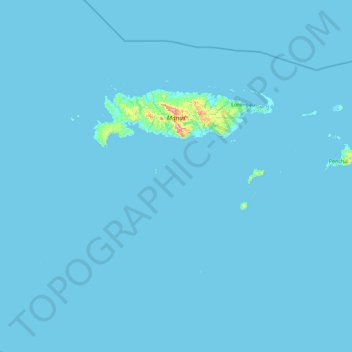
Name: Admiralty Islands topographic map, elevation, terrain.
Average elevation: 5 m
Minimum elevation: -3 m
Maximum elevation: 675 m
Manus reaches an elevation of 700 m (2,300 ft) and is volcanic in origin and probably broke through the ocean's surface in the late Miocene, 8–10 million years ago. The substrate of the island is either directly volcanic or from uplifted coral limestone.
Other topographic maps
Click on a map to view its topography, its elevation and its terrain.
Wuvulu Island
Wuvulu Island, Manus, Islands Region, Papua New Guinea
Average elevation: 3 m
Rambutyo Island
Rambutyo Island, Manus District, Manus, Islands Region, Papua New Guinea
Average elevation: 18 m