
Anacoco topographic map
Interactive map
Click on the map to display elevation.
About this map
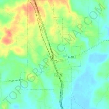
Name: Anacoco topographic map, elevation, terrain.
Location: Anacoco, Vernon Parish, Louisiana, United States (31.23263 -93.35733 31.27649 -93.32917)
Average elevation: 97 m
Minimum elevation: 78 m
Maximum elevation: 129 m
Other topographic maps
Click on a map to view its topography, its elevation and its terrain.
Hornbeck
United States > Louisiana > Vernon Parish
Hornbeck, Vernon Parish, Louisiana, United States
Average elevation: 110 m
Fort Polk
United States > Louisiana > Vernon Parish > Fort Johnson South
Fort Polk, Fort Johnson South, Vernon Parish, Louisiana, 71459, United States
Average elevation: 96 m
Fort Johnson South
United States > Louisiana > Vernon Parish > Fort Johnson South > Fort Polk
Fort Johnson South, Fort Polk, Fort Johnson South, Vernon Parish, Louisiana, United States
Average elevation: 95 m