
Verona topographic map
Interactive map
Click on the map to display elevation.
Verona
Verona has a humid continental climate (Dfa), with warm/hot humid summers and moderately cold winters. The climate is slightly cooler overall than in New York City, especially at night, because there is no urban heat island effect, as well as higher elevation and a more interior location (greater distance away from the moderating effects of the Atlantic Ocean).
About this map
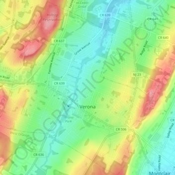
Name: Verona topographic map, elevation, terrain.
Location: Verona, Essex County, New Jersey, 07044, United States (40.81610 -74.26390 40.85086 -74.22099)
Average elevation: 141 m
Minimum elevation: 91 m
Maximum elevation: 211 m
Other topographic maps
Click on a map to view its topography, its elevation and its terrain.
Saint Cloud
United States > New Jersey > Essex County > West Orange > Saint Cloud
Average elevation: 141 m