
Roxboro topographic map
Interactive map
Click on the map to display elevation.
About this map
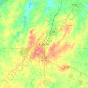
Name: Roxboro topographic map, elevation, terrain.
Location: Roxboro, Person County, North Carolina, 27573, United States (36.33009 -79.01072 36.45819 -78.94375)
Average elevation: 191 m
Minimum elevation: 134 m
Maximum elevation: 270 m
Roxboro receives an average of 7.2 in (180 mm) of snow per winter. Freezing rain and sleet occur most winters, and occasionally the area experiences a major, damaging ice storm. Roxboro is often dubbed the "Snow Capital of the Triangle" because it often receives the most or close to the most snow during snowstorms in central North Carolina due to its high elevation.
Other topographic maps
Click on a map to view its topography, its elevation and its terrain.
Concord
United States > North Carolina > Person County
Concord, Person County, North Carolina, United States
Average elevation: 164 m
Hurdle Mills
United States > North Carolina > Person County > Hurdle Mills
Hurdle Mills, Person County, North Carolina, United States
Average elevation: 189 m
Allensville
United States > North Carolina > Person County > Allensville
Allensville, Person County, North Carolina, United States
Average elevation: 171 m
Person County
United States > North Carolina > Person County
Person County, North Carolina, United States
Average elevation: 171 m