
Kemmelberg topographic map
Interactive map
Click on the map to display elevation.
About this map
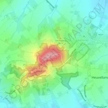
Name: Kemmelberg topographic map, elevation, terrain.
Location: Kemmelberg, Heuvelland, Ieper, West Flanders, 8956, Belgium (50.77896 2.81293 50.77906 2.81303)
Average elevation: 68 m
Minimum elevation: 33 m
Maximum elevation: 153 m
Other topographic maps
Click on a map to view its topography, its elevation and its terrain.
Baneberg
Belgium > West Flanders > Ieper > Heuvelland
Baneberg, Heuvelland, Ieper, West Flanders, Flanders, 8954, Belgium
Average elevation: 83 m
Rodeberg
Belgium > West Flanders > Ieper > Heuvelland
Rodeberg, Heuvelland, Ieper, West Flanders, Flanders, 8954, Belgium
Average elevation: 82 m
Westouter
Belgium > West Flanders > Ieper > Heuvelland > Westouter
Westouter, Heuvelland, Ieper, West Flanders, Flanders, 8954, Belgium
Average elevation: 59 m