
Alexandria topographic map
Interactive map
Click on the map to display elevation.
About this map
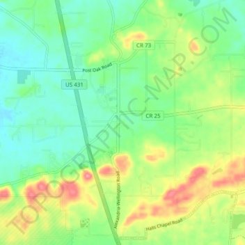
Name: Alexandria topographic map, elevation, terrain.
Location: Alexandria, Calhoun County, Alabama, 36250, United States (33.73876 -85.92260 33.79881 -85.84700)
Average elevation: 188 m
Minimum elevation: 155 m
Maximum elevation: 247 m
Other topographic maps
Click on a map to view its topography, its elevation and its terrain.
Blue Mountain
United States > Alabama > Calhoun County > Anniston
Blue Mountain, Anniston, Calhoun County, Alabama, 36202, United States
Average elevation: 295 m
Jacksonville
United States > Alabama > Calhoun County
Jacksonville, Calhoun County, Alabama, 36265, United States
Average elevation: 251 m
Leydens Mill
United States > Alabama > Calhoun County > Leydens Mill
Leydens Mill, Calhoun County, Alabama, United States
Average elevation: 183 m
Anniston
United States > Alabama > Calhoun County > Anniston
Anniston, Calhoun County, Alabama, United States
Average elevation: 261 m
Ohatchee
United States > Alabama > Calhoun County
Ohatchee, Calhoun County, Alabama, 36271, United States
Average elevation: 171 m