
Town of Williamstown topographic map
Interactive map
Click on the map to display elevation.
About this map
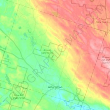
Name: Town of Williamstown topographic map, elevation, terrain.
Average elevation: 235 m
Minimum elevation: 157 m
Maximum elevation: 330 m
Other topographic maps
Click on a map to view its topography, its elevation and its terrain.
Town of Mexico
United States > New York > Oswego County
Town of Mexico, Oswego County, New York, 13114, United States
Average elevation: 119 m
City of Fulton
United States > New York > Oswego County
City of Fulton, Oswego County, New York, 13069, United States
Average elevation: 114 m
Village of Cleveland
United States > New York > Oswego County > Town of Constantia
Village of Cleveland, Town of Constantia, Oswego County, New York, United States
Average elevation: 134 m
Village of Central Square
United States > New York > Oswego County > Village of Central Square
Village of Central Square, Town of Hastings, Oswego County, New York, United States
Average elevation: 126 m
Town of Granby
United States > New York > Oswego County
Town of Granby, Oswego County, New York, 13115, United States
Average elevation: 125 m