
Battle Creek topographic map
Interactive map
Click on the map to display elevation.
About this map
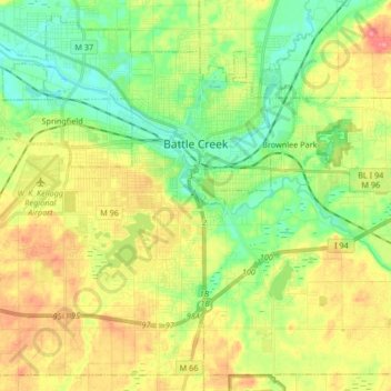
Name: Battle Creek topographic map, elevation, terrain.
Location: Battle Creek, Calhoun County, Michigan, 49015, United States (42.24613 -85.29789 42.35943 -85.13195)
Average elevation: 274 m
Minimum elevation: 243 m
Maximum elevation: 316 m
Other topographic maps
Click on a map to view its topography, its elevation and its terrain.
Sheridan Township
United States > Michigan > Calhoun County
Sheridan Township, Calhoun County, Michigan, United States
Average elevation: 295 m
Clarendon Township
United States > Michigan > Calhoun County
Clarendon Township, Calhoun County, Michigan, United States
Average elevation: 300 m
Burlington Township
United States > Michigan > Calhoun County
Burlington Township, Calhoun County, Michigan, 49029, United States
Average elevation: 283 m
Athens Township
United States > Michigan > Calhoun County
Athens Township, Calhoun County, Michigan, 49011, United States
Average elevation: 274 m