
Disko Island topographic map
Interactive map
Click on the map to display elevation.
About this map
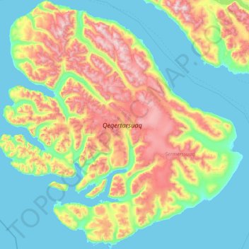
Name: Disko Island topographic map, elevation, terrain.
Location: Disko Island, 3953, Greenland (69.23118 -54.97604 70.33043 -51.84782)
Average elevation: 424 m
Minimum elevation: -3 m
Maximum elevation: 1,943 m
Other topographic maps
Click on a map to view its topography, its elevation and its terrain.
Jakobshavn Glacier
Jakobshavn Glacier, Avannaata, Greenland
Average elevation: 452 m
Ittoqqortoormiit
Ittoqqortoormiit, Sermersooq, 3980, Greenland
Average elevation: 80 m
Kangerlussuaq
Kangerlussuaq, Sisimiut, Qeqqata, Greenland
Average elevation: 114 m
Traill-iup Immikkeertivi
Traill-iup Immikkeertivi, Sermersooq, Greenland
Average elevation: 0 m
Geographical Society Island
Geographical Society Island, Sermersooq, Greenland
Average elevation: 178 m