
North-East District topographic map
Interactive map
Click on the map to display elevation.
About this map
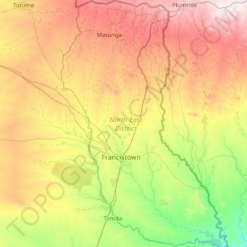
Name: North-East District topographic map, elevation, terrain.
Location: North-East District, Botswana (-21.56780 27.21458 -20.46804 28.01321)
Average elevation: 1,077 m
Minimum elevation: 846 m
Maximum elevation: 1,480 m
Other topographic maps
Click on a map to view its topography, its elevation and its terrain.
Mabuasehube
Mabuasehube, Kgalagadi District, Botswana
Average elevation: 1,045 m
Lokgwabe
Lokgwabe, Kgalagadi District, Botswana
Average elevation: 1,116 m
Boteti River
Boteti River, Central District, Botswana
Average elevation: 914 m
Okavango Delta
Botswana > North-West District
Okavango Delta, North-West District, Botswana
Average elevation: 959 m
Chobe National Park
Chobe National Park, Chobe District, Botswana
Average elevation: 964 m
Makgadikgadi Pans Game Reserve
Makgadikgadi Pans Game Reserve, Central District, Botswana
Average elevation: 917 m
Gaborone
Botswana > South-East District
Gaborone, South-East District, Botswana
Average elevation: 1,032 m
Jwaneng
Botswana > Southern District > Jwaneng
Jwaneng, Southern District, Botswana
Average elevation: 1,193 m
Selebi Phikwe
Botswana > Central District > Selebi Phikwe
Selebi Phikwe, Central District, Botswana
Average elevation: 863 m
Khwai
Botswana > North-West District > Khwai
Khwai, North-West District, Botswana
Average elevation: 939 m
Kalahari Desert
Kalahari Desert, Ghanzi District, Botswana
Average elevation: 1,168 m
Francistown
Botswana > North-East District > Francistown
Francistown, North-East District, Botswana
Average elevation: 1,007 m
Pandamatenga
Pandamatenga, Chobe District, Botswana
Average elevation: 1,074 m
Gaborone Dam
Botswana > South-East District > Gaborone
Gaborone Dam, Gaborone, South-East District, Botswana
Average elevation: 992 m
Letlhakane
Botswana > Central District > Letlhakane
Letlhakane, Central District, NULL, Botswana
Average elevation: 990 m