
Mount Hamilton topographic map
Interactive map
Click on the map to display elevation.
About this map
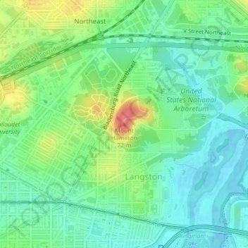
Name: Mount Hamilton topographic map, elevation, terrain.
Average elevation: 23 m
Minimum elevation: -4 m
Maximum elevation: 70 m
Other topographic maps
Click on a map to view its topography, its elevation and its terrain.
National Mall
USA > District of Columbia > Washington
National Mall, Penn Quarter, Washington, District of Columbia, USA
Average elevation: 14 m
Fort Totten Park
USA > District of Columbia > Washington
Fort Totten Park, Fort Totten, Washington, District of Columbia, USA
Average elevation: 63 m
Kingman Lake
USA > District of Columbia > Washington
Kingman Lake, Benning road Bike Path, Washington, District of Columbia, DC 20002, USA
Average elevation: 14 m