
Oita Prefecture topographic map
Interactive map
Click on the map to display elevation.
About this map
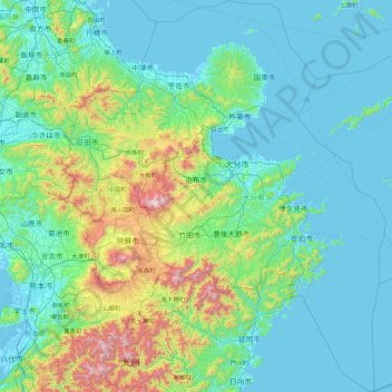
Name: Oita Prefecture topographic map, elevation, terrain.
Location: Oita Prefecture, Japan (32.37889 130.82475 33.84561 132.27609)
Average elevation: 242 m
Minimum elevation: -5 m
Maximum elevation: 1,753 m
The origins of the name Ōita are documented in a report from the early 8th century called the Chronicles of Bungo (豊後国風土記, bungonokuni-fudoki) .[4] According to the document, when Emperor Keikō visited the Kyushu region, stopping first in Toyo-no-kuni, he exclaimed that 'This is a vast land, indeed. It shall be known as Okita-Kuni!' Okita-Kuni, meaning "Land of the Great Fields", later came to be written as "Ōita". Present day interpretations based on Ōita's topography state that Oita's name comes from "Okita", meaning "many fields", rather than "vast" or "great" field, because of Ōita's complex terrain.[4]
Other topographic maps
Click on a map to view its topography, its elevation and its terrain.
Mount Fuji
Japan > Sunto County > Oyama
Mount Fuji, Oyama, Sunto County, Shizuoka Prefecture, Chubu Region, Japan
Average elevation: 3,261 m
Lake Sanaru
Lake Sanaru, Hamamatsu, Shizuoka Prefecture, Chubu Region, Japan
Average elevation: 16 m
Motoyama
Motoyama, Nagaoka County, Kochi Prefecture, 781-3601, Japan
Average elevation: 679 m
Setouchi
Setouchi, Oshima County, Kagoshima Prefecture, Japan
Average elevation: 26 m
Higashishirakawa
Higashishirakawa, Kamo County, Gifu Prefecture, Chubu Region, 509-1392, Japan
Average elevation: 658 m
Nishikigaoka-chuo Park
Nishikigaoka-chuo Park, Nishikigaoka 2-chome, Aoba Ward, Sendai, Miyagi Prefecture, Japan
Average elevation: 197 m
Katsura Imperial Villa
Katsura Imperial Villa, Road No. 142, Katsura-Kasugacho, Nishikyo Ward, Kyoto, Kyoto Prefecture, 615-8013, Japan
Average elevation: 25 m