
Vilseck topographic map
Interactive map
Click on the map to display elevation.
About this map
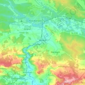
Name: Vilseck topographic map, elevation, terrain.
Location: Vilseck, Landkreis Amberg-Sulzbach, Bavaria, 92249, Germany (49.56417 11.72495 49.65370 11.88355)
Average elevation: 443 m
Minimum elevation: 380 m
Maximum elevation: 583 m
Other topographic maps
Click on a map to view its topography, its elevation and its terrain.
Schmelzmühle
Germany > Bavaria > Landkreis Amberg-Sulzbach > Freihung
Schmelzmühle, Freihung, Landkreis Amberg-Sulzbach, Bavaria, 92271, Germany
Average elevation: 427 m
Bergstein
Germany > Bavaria > Landkreis Amberg-Sulzbach > Illschwang
Bergstein, Illschwang, Illschwang (VGem), Landkreis Amberg-Sulzbach, Bavaria, 92278, Germany
Average elevation: 548 m
Schmidmühlen
Germany > Bavaria > Landkreis Amberg-Sulzbach
Schmidmühlen, Landkreis Amberg-Sulzbach, Bavaria, 92287, Germany
Average elevation: 431 m