
Kirkstone Pass topographic map
Interactive map
Click on the map to display elevation.
About this map
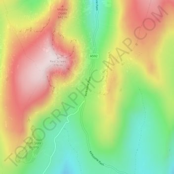
Name: Kirkstone Pass topographic map, elevation, terrain.
Average elevation: 507 m
Minimum elevation: 260 m
Maximum elevation: 774 m
Kirkstone Pass is a mountain pass in the English Lake District, in the county of Cumbria. It is at an altitude of 1,489 feet (454 m).
Other topographic maps
Click on a map to view its topography, its elevation and its terrain.
Helvellyn
United Kingdom > England > Westmorland and Furness > Patterdale
Helvellyn, Patterdale, Westmorland and Furness, England, CA12 4TP, United Kingdom
Average elevation: 680 m