
Evenes topographic map
Interactive map
Click on the map to display elevation.
About this map
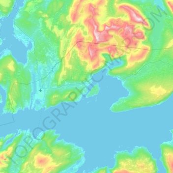
Name: Evenes topographic map, elevation, terrain.
Location: Evenes, Nordland, Norway (68.41740 16.55251 68.57277 17.36162)
Average elevation: 205 m
Minimum elevation: -6 m
Maximum elevation: 1,303 m
Other topographic maps
Click on a map to view its topography, its elevation and its terrain.
Stor-Graddis naturreservat
Stor-Graddis naturreservat, Graddiselv bru, Saltdal, Nordland, Norway
Average elevation: 555 m
Festhaeltinden
Festhaeltinden, Hamnøya, Moskenes, Nordland, Norway
Average elevation: 70 m
Nordkjelda - Latnja
Nordkjelda - Latnja, Narvik, Nordland, Norway
Average elevation: 346 m
Hellandsøya
Norway > Nordland > Henningsvær
Hellandsøya, Henningsvær, Vågan, Nordland, Norway
Average elevation: 0 m
Ballangen - Bálák
Ballangen - Bálák, Narvik, Nordland, Norway
Average elevation: 91 m