
Governors Island topographic map
Interactive map
Click on the map to display elevation.
Governors Island
By the mid-1790s, increased military tensions renewed an interest in fortifying New York Harbor, and a U.S. congressional committee had drawn a map of possible locations for the First System of fortifications to protect major American urban centers. Governors Island was one of the first locations where defenses were built. As such, the agreement with the Board of Regents was voided in 1794, and some $250,000 in federal funding was allocated to the construction of defenses on Governors Island in 1794 and 1795. Fort Jay was built starting in 1794 on the site of the earlier Revolutionary War earthworks. Work proceeded despite concerns that Fort Jay's low elevation made it vulnerable to being captured. Fort Jay, a square four-bastioned fort, was made of earthworks and timber, two impermanent materials that deteriorated soon after the threat of war went away, and by 1805 it had significantly degraded. Ownership of the island was transferred to the federal government on February 15, 1800.
About this map
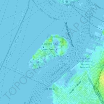
Name: Governors Island topographic map, elevation, terrain.
Average elevation: 1 m
Minimum elevation: -3 m
Maximum elevation: 16 m
Other topographic maps
Click on a map to view its topography, its elevation and its terrain.
Central Park
United States > New York > New York County > New York
In June 1856, Fernando Wood appointed a "consulting board" of seven people, headed by author Washington Irving, to inspire public confidence in the proposed development. Wood hired military engineer Egbert Ludovicus Viele as the park's chief engineer, tasking him with a topographical survey of the site. The…
Average elevation: 26 m
Manhattan Community Board 3
United States > New York > New York County > New York
Average elevation: 10 m
Riverside Park
United States > New York > New York County > New York
Initially, Riverside Avenue had been planned to run in a straight line, which would have required a retaining wall and extensive fill. However, the area's difficult topography had come to the attention of the Manhattan park commissioners. In 1873, the commissioners selected Frederick Law Olmsted, a park…
Average elevation: 17 m
Hunter’s Point South Waterfront Park
United States > New York > New York County > New York
Average elevation: 5 m