
St. Gallen topographic map
Interactive map
Click on the map to display elevation.
About this map
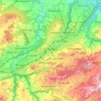
Name: St. Gallen topographic map, elevation, terrain.
Location: St. Gallen, Wahlkreis St. Gallen, St. Gallen, Switzerland (47.39516 9.29151 47.45308 9.43524)
Average elevation: 741 m
Minimum elevation: 467 m
Maximum elevation: 1,128 m
St. Gallen is notable for reporting the highest maximum radioactivity measurements of any Swiss city, as published in the 2009 yearly report by the Federal Office of Public Health. While the daily average level of gamma-ray radioactivity in the city is unremarkable at 105 nSv/h, the maximum can reach 195 nSv/h, as high as the average for Jungfraujoch, the location with the highest reported level of radioactivity in Switzerland, due to its high elevation and therefore greater exposure to cosmic rays. The same report explains that the unusually high spikes of radioactivity measured in St. Gallen are due to radioactive products of radon gas being washed to the ground during heavy storms, but does not explain where the sufficient quantities of radon gas and its products to account for the anomaly would come from. The yearly report for 2009 on risks associated with radon published by the same governmental agency shows St. Gallen to lie in an area of the lowest level of radon exposure. In addition to the measured gamma-radiation, the city may be subject to radioactive tritium pollution in Teufen, a satellite town situated 4 km south of the city in the canton of Appenzell Outer Rhodes (this pollution is also covered in the report).