
Make a donation
Gear up for your next adventure:
As an Amazon Associate, this site earns from qualifying purchases at no extra cost to you.
Carlisle topographic map
Click on the map to display elevation.
Make a donation
Gear up for your next adventure:
As an Amazon Associate, this site earns from qualifying purchases at no extra cost to you.
About this map
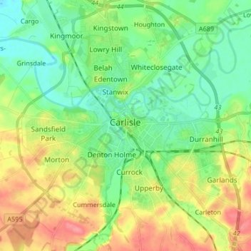
Name: Carlisle topographic map, elevation, terrain.
Location: Carlisle, Cumberland, England, United Kingdom (54.85565 -2.98940 54.93207 -2.87749)
Average elevation: 31 m
Minimum elevation: 5 m
Maximum elevation: 75 m
Cumberland trails, hiking, mountain biking, running and outdoor activities
Make a donation
Gear up for your next adventure:
As an Amazon Associate, this site earns from qualifying purchases at no extra cost to you.
Other topographic maps
Click on a map to view its topography, its elevation and its terrain.
Scafell Pike
United Kingdom > England > Cumberland
Scafell Pike (/ˈskɔːfɛl paɪk/) is the highest and the most prominent mountain in England, at an elevation of 978 metres (3,209 ft) above sea level. It is located in the Lake District National Park, in Cumbria, and is part of the Southern Fells and the Scafell massif.
Average elevation: 679 m
Make a donation
Gear up for your next adventure:
As an Amazon Associate, this site earns from qualifying purchases at no extra cost to you.
Make a donation
Gear up for your next adventure:
As an Amazon Associate, this site earns from qualifying purchases at no extra cost to you.
Solway Coast National Landscape
United Kingdom > England > Cumberland > Rockcliffe
Average elevation: 53 m
Skiddaw
United Kingdom > England > Cumberland
Skiddaw is a mountain in the Lake District National Park in England. Its 931-metre (3,054 ft) summit is traditionally considered to be the fourth-highest peak but depending on what topographic prominence is thought to be significant is also variously ranked as the third- and the sixth-highest in England. It…
Average elevation: 630 m
Make a donation
Gear up for your next adventure:
As an Amazon Associate, this site earns from qualifying purchases at no extra cost to you.
Fleetwith Pike
United Kingdom > England > Cumberland > Buttermere
The fell itself is often climbed in conjunction with other neighbouring fells such as Haystacks and Grey Knotts; strong walkers may also take in the peaks of Great Gable and Green Gable. There are two possible starting points for the ascent of Fleetwith Pike: these are Gatesgarth in the Buttermere valley and…
Average elevation: 360 m
Make a donation
Gear up for your next adventure:
As an Amazon Associate, this site earns from qualifying purchases at no extra cost to you.
Scafell Pike
United Kingdom > England > Cumberland
Scafell Pike (/ˈskɔːfɛl/) is a mountain in the Lake District region of Cumbria, England. It has an elevation of 978 metres (3,209 ft) above sea level, making it the highest and the most prominent mountain in England. The mountain is part of the Scafell massif, an extinct volcano, and is one of the Southern…
Average elevation: 679 m
Harter Fell
United Kingdom > England > Cumberland > Ulpha
Harter Fell offers excellent insights into the structure and composition of the Birker Fell formation of the Ordovician Borrowdale Volcanic Group. The fell is dominantly composed of composite andesite lava flows, with autobrecciated upper surfaces developed in some locations. These are often seen in the field…
Average elevation: 335 m
Make a donation
Gear up for your next adventure:
As an Amazon Associate, this site earns from qualifying purchases at no extra cost to you.
Whin Rigg
United Kingdom > England > Cumberland
Whin Rigg is a fell in the English Lake District, situated in the western segment of the national park, 22 kilometres (14 miles) south east of the town of Whitehaven. It reaches only a modest altitude of 535 m (1,755 ft) but is part of one of the Lake District’s most dramatic landscapes in that the rugged…
Average elevation: 264 m
Make a donation
Gear up for your next adventure:
As an Amazon Associate, this site earns from qualifying purchases at no extra cost to you.
Scafell Pike
United Kingdom > England > Cumberland
Scafell Pike (/ˈskɔːfɛl/) is a hill in the Lake District region of Cumbria, England. It has an elevation of 978 metres (3,209 ft) above sea level, making it the highest and the most prominent mountain in England. The mountain is part of the Scafell massif, an extinct volcano, and is one of the Southern Fells.
Average elevation: 679 m
Make a donation
Gear up for your next adventure:
As an Amazon Associate, this site earns from qualifying purchases at no extra cost to you.
Brund Fell (summit)
United Kingdom > England > Cumberland > Borrowdale
The fell has a summit plateau which consist of many heather-covered hummocks, drystone walls and clumps of trees. Well-known Lake District writer Alfred Wainwright credits Grange Fell as a single fell with three main summits, namely Brund Fell, King's How and Ether Knott. The lesser known Ether Knott is now…
Average elevation: 252 m
Make a donation
Gear up for your next adventure:
As an Amazon Associate, this site earns from qualifying purchases at no extra cost to you.
Scafell Pike
United Kingdom > England > Cumberland
Scafell Pike (/ˈskɔːfɛl/) is a mountain in the Lake District region of Cumbria, England. It has an elevation of 978 metres (3,209 ft) above sea level, making it the highest and the most prominent mountain in England. The mountain is part of the Scafell massif, an extinct volcano, and is one of the Southern…
Average elevation: 679 m
Make a donation
Gear up for your next adventure:
As an Amazon Associate, this site earns from qualifying purchases at no extra cost to you.
Make a donation
Gear up for your next adventure:
As an Amazon Associate, this site earns from qualifying purchases at no extra cost to you.
Make a donation
Gear up for your next adventure:
As an Amazon Associate, this site earns from qualifying purchases at no extra cost to you.
Make a donation
Gear up for your next adventure:
As an Amazon Associate, this site earns from qualifying purchases at no extra cost to you.
Crosby-on-Eden
United Kingdom > England > Cumberland > Low Crosby > High Crosby
Average elevation: 22 m
Make a donation
Gear up for your next adventure:
As an Amazon Associate, this site earns from qualifying purchases at no extra cost to you.
Seatallan
United Kingdom > England > Cumberland
Seatallan is a mountain in the western part of the English Lake District. It is rounded, grassy and fairly unassuming, occupying a large amount of land. However, it is classed as a Marilyn because of the low elevation of the col connecting it to Haycock, its nearest higher neighbour to the north. The name…
Average elevation: 452 m
Black Combe
United Kingdom > England > Cumberland
Walks to the top of the fell begin at St Mary's Church, Whicham to the south; St Mary's Church, Whitbeck to the west or from the Corney Fell Road which crosses the fells at an altitude of 1,250 ft (380 m) 4 miles (6.4 km) to the north of the top. A more challenging and interesting route begins at Beckside Farm…
Average elevation: 360 m
Make a donation
Gear up for your next adventure:
As an Amazon Associate, this site earns from qualifying purchases at no extra cost to you.
Esk Pike
United Kingdom > England > Cumberland
To the north-west of Esk Pike is the depression of Esk Hause, a broad saddle carrying a number of important paths. The ‘true’ Esk Hause—so named by Alfred Wainwright in his influential Pictorial Guide to the Lakeland Fells—is the north–south route from Borrowdale to Eskdale. A lower path—the…
Average elevation: 652 m
Make a donation
Gear up for your next adventure:
As an Amazon Associate, this site earns from qualifying purchases at no extra cost to you.
Make a donation
Gear up for your next adventure:
As an Amazon Associate, this site earns from qualifying purchases at no extra cost to you.
Ard Crags
United Kingdom > England > Cumberland
Ard Crags is a fell in the Lake District in Cumbria, England, it is situated in the Newlands Valley just off the minor road between Keswick and Buttermere. The Ordnance Survey officially records the fell's altitude at 581 metres (1,906 ft), considerably more than the approximate 1,860 feet (570 m) that Alfred…
Average elevation: 420 m
Make a donation
Gear up for your next adventure:
As an Amazon Associate, this site earns from qualifying purchases at no extra cost to you.
Fellbarrow
United Kingdom > England > Cumberland
The two fells form a ridge 2 miles long with the lower Fellbarrow at the northern end. Alfred Wainwright in his influential Pictorial Guide to the Lakeland Fells was forced to estimate the elevation of Low Fell and considered (although with some doubts) Fellbarrow to be the high point of the ridge. There are a…
Average elevation: 256 m
Rannerdale Knotts
United Kingdom > England > Cumberland > Buttermere
The highest ground in the North Western Fells is an east-west ridge in this central sector, beginning with Grasmoor above Crummock Water and then gradually descending eastwards over Crag Hill, Sail, Scar Crags and Causey Pike. Grasmoor has the greatest elevation, but Crag Hill stands at the hub of the range.…
Average elevation: 212 m
Make a donation
Gear up for your next adventure:
As an Amazon Associate, this site earns from qualifying purchases at no extra cost to you.
Ling Fell
United Kingdom > England > Cumberland
Ling Fell and Sale Fell, despite standing side by side, have no topographical connection. Ling Fell's 'parent' is Broom Fell, while Sale Fell is an outlier of Lord's Seat. They are separated by the stream of Wythop Beck which drains a catchment to the east. The two fells act as portals to this shy valley as it…
Average elevation: 249 m
Make a donation
Gear up for your next adventure:
As an Amazon Associate, this site earns from qualifying purchases at no extra cost to you.
Make a donation
Gear up for your next adventure:
As an Amazon Associate, this site earns from qualifying purchases at no extra cost to you.
Seathwaite Fell (Wainwright)
United Kingdom > England > Cumberland > Borrowdale
Average elevation: 511 m
High Spy
United Kingdom > England > Cumberland
The fell reaches a height of 653 metres (2,142 feet) and is defended by crags to the east and west as it falls away steeply to the valleys. It is a distinctive fell that has 148 metres (486 feet) of topographic prominence from the higher adjoining fell of Dale Head and so misses being a Marilyn by only two…
Average elevation: 404 m
Make a donation
Gear up for your next adventure:
As an Amazon Associate, this site earns from qualifying purchases at no extra cost to you.
Scafell Pike
United Kingdom > England > Cumberland
Scafell Pike (/ˈskɔːfɛl paɪk/) is a mountain in the Lake District region of Cumbria, England. It has an elevation of 978 metres (3,209 ft) above sea level, making it the highest and the most prominent mountain in England. The mountain is part of the Scafell massif, an extinct volcano, and is one of the…
Average elevation: 679 m
Make a donation
Gear up for your next adventure:
As an Amazon Associate, this site earns from qualifying purchases at no extra cost to you.
Make a donation
Gear up for your next adventure:
As an Amazon Associate, this site earns from qualifying purchases at no extra cost to you.
Make a donation
Gear up for your next adventure:
As an Amazon Associate, this site earns from qualifying purchases at no extra cost to you.
Make a donation
Gear up for your next adventure:
As an Amazon Associate, this site earns from qualifying purchases at no extra cost to you.