
Maidstone topographic map
Interactive map
Click on the map to display elevation.
About this map
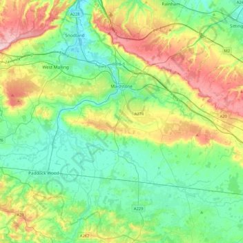
Name: Maidstone topographic map, elevation, terrain.
Location: Maidstone, Kent, England, United Kingdom (51.13395 0.37810 51.33874 0.79644)
Average elevation: 70 m
Minimum elevation: -3 m
Maximum elevation: 230 m
Other topographic maps
Click on a map to view its topography, its elevation and its terrain.
Tonbridge
United Kingdom > England > Kent > Tonbridge and Malling
Tonbridge, Tonbridge and Malling, Kent, England, TN9 2AN, United Kingdom
Average elevation: 55 m
Canterbury
United Kingdom > England > Kent
Canterbury, Kent, England, United Kingdom
Average elevation: 51 m
Dartford
United Kingdom > England > Kent
Dartford, Kent, England, United Kingdom
Average elevation: 40 m
Weatherlees Hill
United Kingdom > England > Kent > Thanet > Ebbsfleet
Weatherlees Hill, Minster, Ebbsfleet, Thanet, Kent, England, CT12 5FH, United Kingdom
Average elevation: 4 m
Gravesend
United Kingdom > England > Kent > Gravesham
Gravesend, Gravesham, Kent, England, United Kingdom
Average elevation: 31 m
Minnis Bay
United Kingdom > England > Kent > Thanet
Minnis Bay, Thanet, Kent, England, CT7 9QR, United Kingdom
Average elevation: 6 m
Oldbury Hill
United Kingdom > England > Kent > Tonbridge and Malling
Oldbury Hill, Tonbridge and Malling, Kent, England, TN15 9DS, United Kingdom
Average elevation: 145 m
Margate
United Kingdom > England > Kent > Thanet
Margate, Thanet, Kent, England, United Kingdom
Average elevation: 22 m
Boughton Aluph
United Kingdom > England > Kent > Ashford > Boughton Lees
Boughton Aluph, Boughton Lees, Ashford, Kent, England, United Kingdom
Average elevation: 78 m
Herne Bay
United Kingdom > England > Kent
Herne Bay, Kent, England, United Kingdom
Average elevation: 17 m
Collier Street
United Kingdom > England > Kent > Maidstone
Collier Street, Maidstone, Kent, England, United Kingdom
Average elevation: 18 m
Hillborough
United Kingdom > England > Kent > Canterbury
Hillborough, Canterbury, Kent, England, CT6 6SP, United Kingdom
Average elevation: 15 m
Herne
United Kingdom > England > Kent > Canterbury
Herne, Canterbury, Kent, England, CT6 7HL, United Kingdom
Average elevation: 30 m
Flip Out
United Kingdom > England > Kent > Ashford
Flip Out, Henwood, Henwood Industrial Estate, Willesborough, Ashford, Kent, England, TN24 8DH, United Kingdom
Average elevation: 43 m
Sittingbourne
United Kingdom > England > Kent > Borough of Swale
Sittingbourne, Borough of Swale, Kent, England, ME10 4AL, United Kingdom
Average elevation: 37 m
Robins Creek
United Kingdom > England > Kent > Gravesham > Northfleet
Robins Creek, Northfleet, Gravesham, Kent, England, United Kingdom
Average elevation: 10 m
Littlebourne
United Kingdom > England > Kent > Canterbury
Littlebourne, Canterbury, Kent, England, United Kingdom
Average elevation: 21 m
Potters Corner
United Kingdom > England > Kent > Ashford
Potters Corner, Westwell, Ashford, Kent, England, TN25 4QB, United Kingdom
Average elevation: 61 m
Langley
United Kingdom > England > Kent > Maidstone
Langley, Maidstone, Kent, England, United Kingdom
Average elevation: 106 m
Whitstable
United Kingdom > England > Kent
Whitstable, Kent, England, United Kingdom
Average elevation: 15 m
Oare Creek
United Kingdom > England > Kent > Borough of Swale > Faversham > Oare
Oare Creek, Faversham, Oare, Borough of Swale, Kent, England, ME13 7TU, United Kingdom
Average elevation: 6 m
Royal Tunbridge Wells
United Kingdom > England > Kent > Tunbridge Wells
Royal Tunbridge Wells, Tunbridge Wells, Kent, England, TN1 2DL, United Kingdom
Average elevation: 99 m
Liverton Street
United Kingdom > England > Kent > Maidstone > Grafty Green
Liverton Street, Lenham, Grafty Green, Maidstone, Kent, England, ME17 2NJ, United Kingdom
Average elevation: 102 m
Park Gate
United Kingdom > England > Kent > Folkestone and Hythe District > Elham
Park Gate, Elham, Folkestone and Hythe District, Kent, England, CT4 6BH, United Kingdom
Average elevation: 130 m
Sevenoaks
United Kingdom > England > Kent > Sevenoaks
Sevenoaks, Kent, England, United Kingdom
Average elevation: 127 m
Norton
United Kingdom > England > Kent > Borough of Swale
Norton, Borough of Swale, Kent, England, ME9 9JU, United Kingdom
Average elevation: 35 m
Charcott
United Kingdom > England > Kent > Sevenoaks > Chiddingstone Causeway
Charcott, Leigh, Chiddingstone Causeway, Sevenoaks, Kent, England, TN11 8LJ, United Kingdom
Average elevation: 53 m
Seed
United Kingdom > England > Kent > Borough of Swale > Doddington
Seed, Newnham, Doddington, Borough of Swale, Kent, England, ME9 0NE, United Kingdom
Average elevation: 101 m
Stowting
United Kingdom > England > Kent > Folkestone and Hythe District
Stowting, Folkestone and Hythe District, Kent, England, United Kingdom
Average elevation: 148 m
Boughton under Blean
United Kingdom > England > Kent > Borough of Swale
Boughton under Blean, Borough of Swale, Kent, England, United Kingdom
Average elevation: 48 m
Shorne Wood
United Kingdom > England > Kent > Gravesham > Shorne Ridgeway
Shorne Wood, Shorne, Shorne Ridgeway, Gravesham, Kent, England, DA12 3HX, United Kingdom
Average elevation: 83 m
Graveney
United Kingdom > England > Kent > Borough of Swale
Graveney, Borough of Swale, Kent, England, ME13 9DZ, United Kingdom
Average elevation: 8 m
Istead Rise
United Kingdom > England > Kent > Gravesham
Istead Rise, Gravesham, Kent, England, DA13 9JT, United Kingdom
Average elevation: 63 m
Stodmarsh
United Kingdom > England > Kent > Canterbury > Wickhambreaux
Stodmarsh, Wickhambreaux, Canterbury, Kent, England, CT3 4BD, United Kingdom
Average elevation: 12 m
Frittenden
United Kingdom > England > Kent > Tunbridge Wells
Frittenden, Tunbridge Wells, Kent, England, United Kingdom
Average elevation: 34 m
Ryarsh
United Kingdom > England > Kent > Tonbridge and Malling
Ryarsh, Tonbridge and Malling, Kent, England, United Kingdom
Average elevation: 57 m
Rusthall Common Cricket Ground
United Kingdom > England > Kent > Tunbridge Wells > Rusthall
Rusthall Common Cricket Ground, Rusthall, Tunbridge Wells, Kent, England, United Kingdom
Average elevation: 99 m
Hartley
United Kingdom > England > Kent > Sevenoaks
Hartley, Sevenoaks, Kent, England, United Kingdom
Average elevation: 99 m
Brookland
United Kingdom > England > Kent > Folkestone and Hythe District
Brookland, Folkestone and Hythe District, Kent, England, United Kingdom
Average elevation: 2 m
Sundridge
United Kingdom > England > Kent > Sevenoaks
Sundridge, Sevenoaks, Kent, England, TN14 6ES, United Kingdom
Average elevation: 116 m
Clement Street
United Kingdom > England > Kent > Dartford > Hawley
Clement Street, Sutton-at-Hone and Hawley, Hawley, Dartford, Kent, England, BR8 7PE, United Kingdom
Average elevation: 47 m
Fairseat
United Kingdom > England > Kent > Tonbridge and Malling
Fairseat, Stansted, Tonbridge and Malling, Kent, England, TN15 7LU, United Kingdom
Average elevation: 164 m
Craylands Gorge
United Kingdom > England > Kent > Dartford > Swanscombe
Craylands Gorge, Swanscombe and Greenhithe, Swanscombe, Dartford, Kent, England, United Kingdom
Average elevation: 19 m
Chalybeate Spring
United Kingdom > England > Kent > Tunbridge Wells > Kilndown
Chalybeate Spring, Spring Walk, Lamberhurst, Kilndown, Tunbridge Wells, Kent, England, TN3 8JB, United Kingdom
Average elevation: 65 m
Little Hermitage
United Kingdom > England > Kent > Gravesham > Higham
Little Hermitage, Higham, Gravesham, Kent, England, ME3 7NU, United Kingdom
Average elevation: 49 m
Preston
United Kingdom > England > Kent > Dover
Preston, Dover, Kent, England, United Kingdom
Average elevation: 10 m