
Binche topographic map
Interactive map
Click on the map to display elevation.
About this map
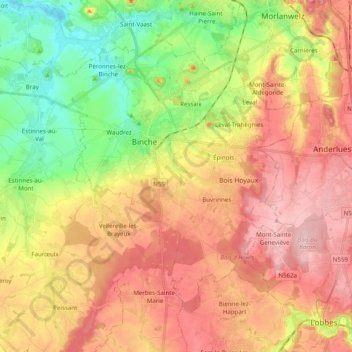
Name: Binche topographic map, elevation, terrain.
Location: Binche, La Louvière, Hainaut, Wallonia, Belgium (50.34925 4.05597 50.44691 4.25250)
Average elevation: 127 m
Minimum elevation: 44 m
Maximum elevation: 214 m
Other topographic maps
Click on a map to view its topography, its elevation and its terrain.
Baume
Belgium > Hainaut > La Louvière > La Louvière
Baume, La Louvière, Hainaut, Wallonia, 7100, Belgium
Average elevation: 122 m
Houdeng-Gœgnies
Belgium > Hainaut > La Louvière > La Louvière > Houdeng-Gœgnies
Houdeng-Gœgnies, La Louvière, Hainaut, Wallonia, 7110, Belgium
Average elevation: 115 m
La Louvière
Belgium > Hainaut > La Louvière
La Louvière, Hainaut, Wallonia, 7100, Belgium
Average elevation: 113 m