
Triglav topographic map
Interactive map
Click on the map to display elevation.
About this map
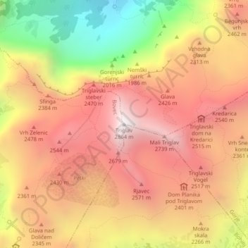
Name: Triglav topographic map, elevation, terrain.
Location: Triglav, Bohinj, Slovenia (46.37825 13.83653 46.37835 13.83663)
Average elevation: 2,161 m
Minimum elevation: 1,169 m
Maximum elevation: 2,835 m
Triglav (pronounced ; German: Terglau; Italian: Tricorno), with an elevation of 2,863.65 metres (9,395.2 ft), is the highest mountain in Slovenia and the highest peak of the Julian Alps. The mountain is the pre-eminent symbol of the Slovene nation. It is the centrepiece of Triglav National Park, Slovenia's only national park. Triglav was also the highest peak in Yugoslavia before Slovenia's independence in 1991.
Other topographic maps
Click on a map to view its topography, its elevation and its terrain.
Bertoki / Bertocchi
Slovenia > Koper / Capodistria
Bertoki / Bertocchi, Koper / Capodistria, Upravna enota Koper / Unità amministrativa Capodistria, 6104, Slovenia
Average elevation: 27 m
Podpeč
Slovenia > Koper / Capodistria
Podpeč, Koper / Capodistria, Upravna enota Koper / Unità amministrativa Capodistria, 6275, Slovenia
Average elevation: 323 m
Šmarje
Slovenia > Koper / Capodistria
Šmarje, Koper / Capodistria, Upravna enota Koper / Unità amministrativa Capodistria, 6274, Slovenia
Average elevation: 203 m
Dolnji Lakoš / Alsólakos
Dolnji Lakoš / Alsólakos, Lendava / Lendva, 9220, Slovenia
Average elevation: 168 m
Pristava pri Lesičnem
Pristava pri Lesičnem, Podčetrtek, 3261, Slovenia
Average elevation: 378 m
Bebar
Slovenia > Zagorje ob Savi > Vrh
Bebar, Vrh, Zagorje ob Savi, 1410, Slovenia
Average elevation: 430 m
Zbelovo
Zbelovo, Slovenske Konjice, 3215, Slovenia
Average elevation: 322 m