
Säynätsalo topographic map
Interactive map
Click on the map to display elevation.
About this map
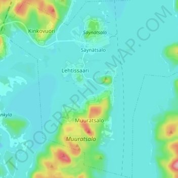
Name: Säynätsalo topographic map, elevation, terrain.
Average elevation: 93 m
Minimum elevation: 74 m
Maximum elevation: 208 m
Other topographic maps
Click on a map to view its topography, its elevation and its terrain.
Muuratsalo
Finland > Western Finland > Jyväskylä
Muuratsalo, Jyväskylä, Jyväskylä sub-region, Central Finland, Western and Central Finland, Western Finland, Mainland Finland, Finland
Average elevation: 94 m