
Switzerland topographic map
Interactive map
Click on the map to display elevation.
About this map
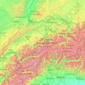
Name: Switzerland topographic map, elevation, terrain.
Location: Switzerland (45.81797 5.95591 47.80846 10.49229)
Average elevation: 1,016 m
Minimum elevation: 41 m
Maximum elevation: 4,564 m
Switzerland lies between latitudes 45° and 48° N, and longitudes 5° and 11° E. It contains three basic topographical areas: the Swiss Alps to the south, the Swiss Plateau or Central Plateau, and the Jura mountains on the west. The Alps are a mountain range running across the central and south of the country, constituting about 60% of the country's area. The majority of the population live on the Swiss Plateau. The Swiss Alps host many glaciers, covering 1,063 square kilometres (410 sq mi). From these originate the headwaters of several major rivers, such as the Rhine, Inn, Ticino and Rhône, which flow in the four cardinal directions, spreading across Europe. The hydrographic network includes several of the largest bodies of fresh water in Central and Western Europe, among which are Lake Geneva (Lac Léman in French), Lake Constance (Bodensee in German) and Lake Maggiore. Switzerland has more than 1500 lakes and contains 6% of Europe's freshwater stock. Lakes and glaciers cover about 6% of the national territory. Lake Geneva is the largest lake and is shared with France. The Rhône is both the main source and outflow of Lake Geneva. Lake Constance is the second-largest and, like Lake Geneva, an intermediate step by the Rhine at the border with Austria and Germany. While the Rhône flows into the Mediterranean Sea at the French Camargue region and the Rhine flows into the North Sea at Rotterdam, about 1,000 kilometres (620 miles) apart, both springs are only about 22 kilometres (14 miles) apart in the Swiss Alps.
Other topographic maps
Click on a map to view its topography, its elevation and its terrain.
The World
United Arab Emirates > Dubai > Dubai
The World, Dubai, United Arab Emirates
Average elevation: 0 m
United Kingdom
United Kingdom
Average elevation: 42 m
Europe
Europe
Average elevation: 223 m
London
United Kingdom > England > London
London, Greater London, England, SW1A 2DX, United Kingdom
Average elevation: 42 m
Ukraine
Ukraine
Average elevation: 183 m
Spain
Spain
Average elevation: 331 m
Sweden
Sweden
Average elevation: 163 m
Germany
Germany
Average elevation: 237 m
United States
United States
Average elevation: 309 m
Kazakhstan
Kazakhstan
Average elevation: 703 m
Bengaluru
India > Karnataka > Bangalore North
Bengaluru, Bangalore North, Bengaluru Urban District, Karnataka, India
Average elevation: 881 m
India
India
Average elevation: 1,017 m
Africa
Africa
Average elevation: 462 m
Italy
Italy
Average elevation: 293 m
Turkey
Turkey
Average elevation: 487 m
Iran
Iran
Average elevation: 786 m
Indonesia
Indonesia
Average elevation: 81 m
United Arab Emirates
United Arab Emirates
Average elevation: 85 m
Romania
Romania
Average elevation: 355 m
Chennai
India > Tamil Nadu > Chennai
Chennai, Chennai District, Tamil Nadu, India
Average elevation: 8 m
Israel
Israel
Average elevation: 410 m
Greece
Greece
Average elevation: 170 m
Japan
Japan
Average elevation: 58 m
Netherlands
Netherlands
Average elevation: 251 m
London
London, Greater London, England, United Kingdom
Average elevation: 66 m
North America
North America
Average elevation: 294 m
Belgium
Belgium
Average elevation: 138 m
China
China
Average elevation: 901 m
Australia
Australia
Average elevation: 35 m
Winchester
United Kingdom > England > Hampshire
Winchester, Hampshire, England, United Kingdom
Average elevation: 73 m