
Dhulikhel topographic map
Interactive map
Click on the map to display elevation.
About this map
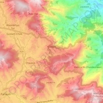
Name: Dhulikhel topographic map, elevation, terrain.
Location: Dhulikhel, Kavrepalanchok, Bagmati Pradesh, Nepal (27.59224 85.53050 27.63848 85.61317)
Average elevation: 1,436 m
Minimum elevation: 903 m
Maximum elevation: 1,816 m
Other topographic maps
Click on a map to view its topography, its elevation and its terrain.
Banepa
Banepa, Kavrepalanchok, Bagmati Pradesh, Nepal
Average elevation: 1,559 m
Nagarkot
Nepal > Kavrepalanchok > Tukucha Nala
Nagarkot, Tukucha Nala, Banepa, Kavrepalanchok, Bagmati Pradesh, 44812, Nepal
Average elevation: 1,886 m