
Farnham Common topographic map
Interactive map
Click on the map to display elevation.
About this map
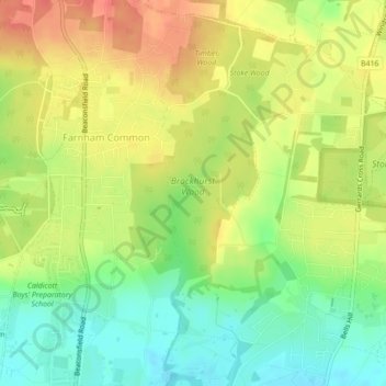
Name: Farnham Common topographic map, elevation, terrain.
Average elevation: 73 m
Minimum elevation: 46 m
Maximum elevation: 97 m
Other topographic maps
Click on a map to view its topography, its elevation and its terrain.
South Bucks
United Kingdom > England > South Bucks
South Bucks, Buckinghamshire, South East, England, United Kingdom
Average elevation: 61 m
Colne Brook
United Kingdom > England > South Bucks
Colne Brook, South Bucks, Buckinghamshire, South East, England, SL0 9AJ, United Kingdom
Average elevation: 30 m
River Misbourne
United Kingdom > England > South Bucks
River Misbourne, Buckinghamshire, South East, England, UB9 5AS, United Kingdom
Average elevation: 42 m