
Al Wakrah topographic map
Interactive map
Click on the map to display elevation.
About this map
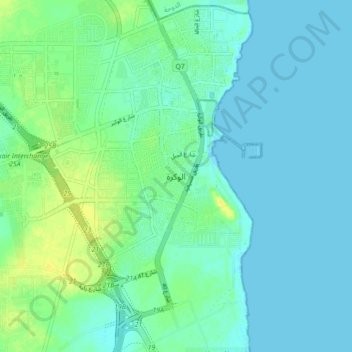
Name: Al Wakrah topographic map, elevation, terrain.
Location: Al Wakrah, 82707, Qatar (25.11666 51.56132 25.19666 51.64132)
Average elevation: 6 m
Minimum elevation: -1 m
Maximum elevation: 20 m
Previously, Al Wakrah's largest mosque was Al Ayouni Mosque, constructed around 1935. It was built near the coast because it was the most active and populated section of the city. After a new mosque was built closer to the main road, the mosque became defunct. It has a square shape, measures 16 m by 17 m, and lies 67 cm above ground elevation. A rare characteristic of the mosque is its single entrance on the east side; a majority of other mosques in Qatar constructed during this period had three entrances. The outdoor praying area is accessible from five pathways separated by narrow columns. Adjacent to this is the prayer hall, which can be accessed from three different entrances in the outdoor area.