
Tonle Sap Lake topographic map
Interactive map
Click on the map to display elevation.
About this map
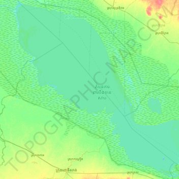
Name: Tonle Sap Lake topographic map, elevation, terrain.
Location: Tonle Sap Lake, Pursat, Cambodia (12.51162 103.69277 13.26139 104.47160)
Average elevation: 8 m
Minimum elevation: 0 m
Maximum elevation: 44 m
The land cover of the Tonlé Sap Lake Basin is 55% of the forest land and 45% of the agricultural land. The lake is surrounded by freshwater mangroves known as "flood forests", accounting for 3% of the basin area, and the floodplain is surrounded by low hills and covered with evergreen or deciduous seasonal tropical The forest is dominated by Dipterocarpaceae, Leguminosae, Lacelandaceae, and in some places Pinaceae, Rohan pineaceae or bamboo. As the distance from the lake becomes farther and farther away, the forest gradually turns into a thicket, and finally into a meadow. In areas with higher quality soils or higher altitudes, deciduous mixed forests and semi-evergreen forests occur. This diversity of vegetation types underlies the species diversity of the Tonle Sap ecosystem, with interlocking forests, grasslands and swamps providing refuge for local wildlife.
Other topographic maps
Click on a map to view its topography, its elevation and its terrain.