
Pembrokeshire Coast National Park topographic map
Click on the map to display elevation.
About this map
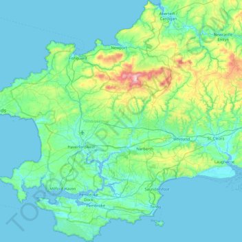
Name: Pembrokeshire Coast National Park topographic map, elevation, terrain.
Average elevation: 69 m
Minimum elevation: 0 m
Maximum elevation: 530 m
Pembrokeshire trails, hiking, mountain biking, running and outdoor activities
Other topographic maps
Click on a map to view its topography, its elevation and its terrain.
Preseli Mountains
United Kingdom > Wales > Pembrokeshire > Puncheston
Samuel Lewis's A Topographical Dictionary of Wales published in 1833 said of Maenclochog parish.
Average elevation: 217 m
Square and Compass
United Kingdom > Wales > Pembrokeshire > St Davids > Square and Compass
Average elevation: 91 m
Walton West
United Kingdom > Wales > Pembrokeshire > Broad Haven > Walton West
Average elevation: 45 m