
Make a donation
Gear up for your next adventure:
As an Amazon Associate, this site earns from qualifying purchases at no extra cost to you.
Mount Ruapehu topographic map
Click on the map to display elevation.
Make a donation
Gear up for your next adventure:
As an Amazon Associate, this site earns from qualifying purchases at no extra cost to you.
About this map
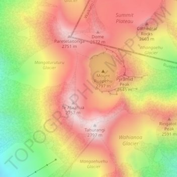
Name: Mount Ruapehu topographic map, elevation, terrain.
Average elevation: 2,439 m
Minimum elevation: 1,994 m
Maximum elevation: 2,755 m
Make a donation
Gear up for your next adventure:
As an Amazon Associate, this site earns from qualifying purchases at no extra cost to you.
Other topographic maps
Click on a map to view its topography, its elevation and its terrain.
South Island
The South Island, also officially named Te Waipounamu, is the larger of the two major islands of New Zealand in surface area, the other being the smaller but more populous North Island. It is bordered to the north by Cook Strait, to the west by the Tasman Sea, and to the south and east by the Pacific Ocean.…
Average elevation: 201 m
Make a donation
Gear up for your next adventure:
As an Amazon Associate, this site earns from qualifying purchases at no extra cost to you.
South Island
The South Island (Māori: Te Waipounamu, lit. 'the waters of Greenstone', officially South Island or Te Waipounamu or archaically New Munster) is the largest of the three major islands of New Zealand in surface area, the other being the smaller but more populous North Island and sparsely populated Stewart…
Average elevation: 201 m
Make a donation
Gear up for your next adventure:
As an Amazon Associate, this site earns from qualifying purchases at no extra cost to you.
Napier
The topography puts Napier in danger from a tsunami, as the centre of the commercial city is near sea level – should the sea ever crest Marine Parade, the sea would run through to Ahuriri. Furthermore, by virtue of its pre-1931 existence, the bulk of Napier is susceptible to soil liquefaction, the risk…
Average elevation: 12 m
Southland
Fiordland has a wet mountain climate though conditions vary due to altitude and exposure. Rainfall is the highest in the country and varies between 6,500 and 7,500 mm annually. The farthest coastal reaches of Fiordland are characterized by a limited temperature range with increasing rainfall at higher…
Average elevation: 229 m
Make a donation
Gear up for your next adventure:
As an Amazon Associate, this site earns from qualifying purchases at no extra cost to you.
Aoraki / Mount Cook National Park
New Zealand > Canterbury > Mackenzie District
Temperatures in Mount Cook Village range between extremes of −13 °C (9 °F) to 32 °C (90 °F), and typically fall just over 1 °C (34 °F) for every 200 metres (660 ft) of additional altitude.
Average elevation: 1,386 m
Hector River
New Zealand > Wellington > South Wairarapa District > Greytown Community
Average elevation: 779 m
Make a donation
Gear up for your next adventure:
As an Amazon Associate, this site earns from qualifying purchases at no extra cost to you.
Make a donation
Gear up for your next adventure:
As an Amazon Associate, this site earns from qualifying purchases at no extra cost to you.
Make a donation
Gear up for your next adventure:
As an Amazon Associate, this site earns from qualifying purchases at no extra cost to you.
Make a donation
Gear up for your next adventure:
As an Amazon Associate, this site earns from qualifying purchases at no extra cost to you.
Make a donation
Gear up for your next adventure:
As an Amazon Associate, this site earns from qualifying purchases at no extra cost to you.
Make a donation
Gear up for your next adventure:
As an Amazon Associate, this site earns from qualifying purchases at no extra cost to you.
Clutha River
The Clutha River drains the high mountains of the Southern Alps in the west and passes through a complex topographic system of basins and ranges towards the east before reaching into the Pacific Ocean. A majority of the topographical features of the Clutha River catchment area are a direct result of the late…
Average elevation: 555 m
Make a donation
Gear up for your next adventure:
As an Amazon Associate, this site earns from qualifying purchases at no extra cost to you.
Make a donation
Gear up for your next adventure:
As an Amazon Associate, this site earns from qualifying purchases at no extra cost to you.
Rangitaiki River
The river is 155 kilometres (96 mi) long, rising at an elevation of 740 metres (2,430 ft) above mean sea level, 32 kilometres (20 mi) east of Lake Taupō and 130 kilometres (81 mi) south of the Bay of Plenty coast. From its source in the Ahimanawa Ranges, at the confluence of the Tirikahu Stream and the…
Average elevation: 465 m
Make a donation
Gear up for your next adventure:
As an Amazon Associate, this site earns from qualifying purchases at no extra cost to you.
Make a donation
Gear up for your next adventure:
As an Amazon Associate, this site earns from qualifying purchases at no extra cost to you.
Make a donation
Gear up for your next adventure:
As an Amazon Associate, this site earns from qualifying purchases at no extra cost to you.
Make a donation
Gear up for your next adventure:
As an Amazon Associate, this site earns from qualifying purchases at no extra cost to you.
Mangawhero River
New Zealand > Manawatu-Whanganui
The source of the Mangawhero River is located on the slopes of Mt Ruapehu at elevation of approximately 1,800 m (5,900 ft). The river begins within the area of the Tūroa skifield and flows down the slopes of the mountain in a south west direction. The Ohakune Mountain Road, built during the 1950s and 60s,…
Average elevation: 460 m
Make a donation
Gear up for your next adventure:
As an Amazon Associate, this site earns from qualifying purchases at no extra cost to you.
Make a donation
Gear up for your next adventure:
As an Amazon Associate, this site earns from qualifying purchases at no extra cost to you.
Cook Strait
The strait is named after James Cook, the first European commander to sail through it, in 1770. The waters of Cook Strait are dominated by strong tidal flows. The tidal flow through Cook Strait is unusual in that the tidal elevation at the ends of the strait are almost exactly out of phase with one another, so…
Average elevation: 70 m
Make a donation
Gear up for your next adventure:
As an Amazon Associate, this site earns from qualifying purchases at no extra cost to you.
Kahurangi National Park
The special character of flora and fauna in the region was recognised prior to 1920. One particular example is the Gouland Downs, an area with unusual geology and vegetation, situated at around 600 m (2,000 ft) elevation to the west of Mt Perry. The Gouland Downs was one of eleven sanctuaries designated by the…
Average elevation: 338 m
Mount Aspiring National Park
Mount Aspiring National Park covers 3,562 square kilometres (1,375 mi2) at the southern end of the Southern Alps, directly to the west of Lake Wānaka, and is popular for tramping, walking and mountaineering. Mount Aspiring / Tititea, elevation 3,033 metres (9,951 ft) above sea level, gives the park its name.…
Average elevation: 770 m
Westland Tai Poutini National Park
Westland Tai Poutini National Park covers 1,320 square kilometres (510 sq mi) exclusively on the western side of the South Island's main divide, making it New Zealand's fifth largest national park. The park covers a wide variety of environments, ranging from high alpine tundra near the park's border with…
Average elevation: 685 m
Make a donation
Gear up for your next adventure:
As an Amazon Associate, this site earns from qualifying purchases at no extra cost to you.
Mount Richmond Forest Park
Established in 1977, the forest park is located between Nelson and Marlborough and consists of 1,659 km2 (641 sq mi) of conservation estate. Around 80% of the area is covered in bush. The most notable peak in the forest park is Mount Richmond, which has an elevation above sea level of 1,760 metres (5,770 ft).
Average elevation: 403 m
Tararua Forest Park
The park supports diverse ecosystems, from lowland podocarp-broadleaf forest to alpine tussock tops. Common canopy trees include rimu, rātā, kāmahi and tawa, with beech forest dominating higher elevations. The alpine zone features tussocks, leatherwood and alpine herbs.
Average elevation: 276 m
Make a donation
Gear up for your next adventure:
As an Amazon Associate, this site earns from qualifying purchases at no extra cost to you.
Make a donation
Gear up for your next adventure:
As an Amazon Associate, this site earns from qualifying purchases at no extra cost to you.
Make a donation
Gear up for your next adventure:
As an Amazon Associate, this site earns from qualifying purchases at no extra cost to you.
Spenser Mountains
New Zealand > Tasman > Hurunui District
The Spenser Mountains is a topographic landform in the northern South Island of New Zealand. Located at the southern end of the Nelson Lakes National Park and north of the Lewis Pass they form a natural border between the Canterbury and Tasman regions. Several peaks are named after characters in Edmund…
Average elevation: 1,310 m
Make a donation
Gear up for your next adventure:
As an Amazon Associate, this site earns from qualifying purchases at no extra cost to you.
Make a donation
Gear up for your next adventure:
As an Amazon Associate, this site earns from qualifying purchases at no extra cost to you.
Make a donation
Gear up for your next adventure:
As an Amazon Associate, this site earns from qualifying purchases at no extra cost to you.