
Chepping Wycombe topographic map
Interactive map
Click on the map to display elevation.
About this map
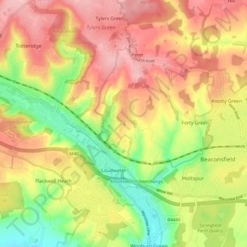
Name: Chepping Wycombe topographic map, elevation, terrain.
Average elevation: 112 m
Minimum elevation: 32 m
Maximum elevation: 178 m
Other topographic maps
Click on a map to view its topography, its elevation and its terrain.
Wooburn
United Kingdom > England > Wycombe
Wooburn, Wycombe, Buckinghamshire, South East, England, United Kingdom
Average elevation: 74 m
The Lyde
United Kingdom > England > Wycombe
The Lyde, Wycombe, Buckinghamshire, South East, England, HP27 9PP, United Kingdom
Average elevation: 106 m
Hedsor
United Kingdom > England > Wycombe
Hedsor, Wycombe, Buckinghamshire, South East, England, United Kingdom
Average elevation: 65 m
Great Marlow
United Kingdom > England > Wycombe
Great Marlow, Wycombe, Buckinghamshire, South East, England, United Kingdom
Average elevation: 101 m
Great and Little Kimble cum Marsh
United Kingdom > England > Wycombe
Great and Little Kimble cum Marsh, Wycombe, Buckinghamshire, South East, England, United Kingdom
Average elevation: 108 m
Great and Little Hampden
United Kingdom > England > Wycombe
Great and Little Hampden, Wycombe, Buckinghamshire, South East, England, United Kingdom
Average elevation: 199 m