
Metropolitan France topographic map
Click on the map to display elevation.
About this map
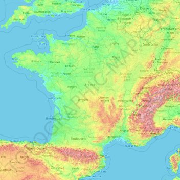
Name: Metropolitan France topographic map, elevation, terrain.
Location: Metropolitan France, France (41.26112 -5.45177 51.30557 9.82822)
Average elevation: 300 m
Minimum elevation: -3 m
Maximum elevation: 4,155 m
Other topographic maps
Click on a map to view its topography, its elevation and its terrain.
Grandes Jorasses / Pointe Walker
France > Auvergne-Rhône-Alpes > Upper Savoy > Chamonix-Mont-Blanc
Average elevation: 3,199 m
Bourg d'en Haut
France > Auvergne-Rhône-Alpes > Upper Savoy > Collonges-sous-Salève > Collonges-sous-Salève
Average elevation: 624 m
Point de vue sur la tourbière des dauges
France > Nouvelle-Aquitaine > Haute-Vienne > Saint-Léger-la-Montagne > Marzet
Average elevation: 581 m
Paris
Paris in its early history had only the rivers Seine and Bièvre for water. From 1809, the Canal de l'Ourcq provided Paris with water from less-polluted rivers to the north-east of the capital. From 1857, the civil engineer Eugène Belgrand, under Napoleon III, oversaw the construction of a series of new…
Average elevation: 75 m
Aix-en-Provence
France > Provence-Alpes-Côte d'Azur > Bouches-du-Rhône > Aix-en-Provence
Average elevation: 279 m
Notre-Dame du Laus
France > Provence-Alpes-Côte d'Azur > Hautes-Alpes > Saint-Étienne-le-Laus
Average elevation: 951 m
Mont Blanc / Monte Bianco
France > Auvergne-Rhône-Alpes > Upper Savoy > Saint-Gervais-les-Bains
The climate is cold and temperate (Köppen climate classification Cfb), and is greatly influenced by altitude. Being the highest part of the Alps, Mont Blanc and surrounding mountains can create their own weather patterns. Temperatures drop as the mountains gain in height, and the summit of Mont Blanc is a…
Average elevation: 4,092 m
Urdazuri
France > Nouvelle-Aquitaine > Pyrénées-Atlantiques > Saint-Jean-de-Luz
Average elevation: 23 m
Ondres
France > Provence-Alpes-Côte d'Azur > Alpes-de-Haute-Provence > Thorame-Haute
Average elevation: 1,441 m
Saint-Seurin
France > Nouvelle-Aquitaine > Charente > Barbezieux-Saint-Hilaire
Average elevation: 78 m
Mont Blanc / Monte Bianco
France > Auvergne-Rhône-Alpes > Upper Savoy > Saint-Gervais-les-Bains
The climate is cold and temperate (Köppen climate classification Cfb), and is greatly influenced by altitude. Being the highest part of the Alps, Mont Blanc and surrounding mountains can create their own weather patterns. Temperatures drop as the mountains gain in height, and the summit of Mont Blanc is a…
Average elevation: 4,092 m
Coun du Pied
France > Provence-Alpes-Côte d'Azur > Hautes-Alpes > Cervières
Average elevation: 1,878 m
Chalets de Fontaine
France > Auvergne-Rhône-Alpes > Upper Savoy > Vacheresse
Average elevation: 1,519 m
Mont Blanc / Monte Bianco
France > Auvergne-Rhône-Alpes > Upper Savoy > Saint-Gervais-les-Bains
The climate is cold and temperate (Köppen climate classification Cfb), and is greatly influenced by altitude. Being the highest part of the Alps, Mont Blanc and surrounding mountains can create their own weather patterns. Temperatures drop as the mountains gain in height, and the summit of Mont Blanc is a…
Average elevation: 4,092 m
La Pimpevinière
France > Nouvelle-Aquitaine > Charente-Maritime > Marennes-Hiers-Brouage
Average elevation: 7 m
Plan de Campagne
France > Provence-Alpes-Côte d'Azur > Bouches-du-Rhône > Les Pennes-Mirabeau
Average elevation: 231 m
Maison Forestière des Cordelières
France > Centre-Val de Loire > Loiret > Vitry-aux-Loges
Average elevation: 124 m
Giratoire du Mât de Ricca
France > Provence-Alpes-Côte d'Azur > Bouches-du-Rhône > Port-Saint-Louis-du-Rhône
Average elevation: 0 m
Sommet de Tigne
France > Provence-Alpes-Côte d'Azur > Alpes-de-Haute-Provence > Volonne
Average elevation: 584 m
Les Mas de Guerrevieille
France > Provence-Alpes-Côte d'Azur > Var > Sainte-Maxime
Average elevation: 60 m