
Make a donation
Gear up for your next adventure:
As an Amazon Associate, this site earns from qualifying purchases at no extra cost to you.
Perito Moreno Glacier topographic map
Click on the map to display elevation.
Make a donation
Gear up for your next adventure:
As an Amazon Associate, this site earns from qualifying purchases at no extra cost to you.
Perito Moreno Glacier
Occasionally, the glacial front does not completely obstruct the natural passage of water with an ice dam, but it approaches close enough to prevent water from passing freely, so without reaching elevation, an arm cut in Rico occurs. These events are classified as minor downloads. This is what happened in October 1996, when the Rico arm rose about a meter. At the end of that month the water pressure opened a greater passage in the walls of the glacial front and the discharge began, but slowly, since the passage had not been sufficiently open, so the maximum peak of the discharge flow occurred at the end of January with a value of 123 m³ / s, the dimensions being equalized on both sides only at the beginning of April.8 The events of 1994, 1995 and 1997 show similar behavior and magnitudes to those of 1996.
Make a donation
Gear up for your next adventure:
As an Amazon Associate, this site earns from qualifying purchases at no extra cost to you.
About this map
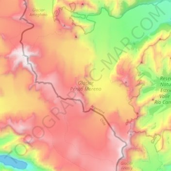
Name: Perito Moreno Glacier topographic map, elevation, terrain.
Average elevation: 1,451 m
Minimum elevation: -3 m
Maximum elevation: 2,832 m
Make a donation
Gear up for your next adventure:
As an Amazon Associate, this site earns from qualifying purchases at no extra cost to you.
Other topographic maps
Click on a map to view its topography, its elevation and its terrain.