Andros topographic map
Interactive map
Click on the map to display elevation.
About this map
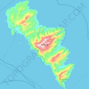
Name: Andros topographic map, elevation, terrain.
Location: Andros, Andros Regional Unit, South Aegean, Aegean, Greece (37.68211 24.68046 37.99958 25.00076)
Average elevation: 83 m
Minimum elevation: 0 m
Maximum elevation: 994 m
Other topographic maps
Click on a map to view its topography, its elevation and its terrain.
Kochylos
Greece > Aegean > Andros Regional Unit
Kochylos, Municipality of Andros, Andros Regional Unit, South Aegean, Aegean, 845 02, Greece
Average elevation: 296 m
Gavrio
Greece > Aegean > Andros Regional Unit
Gavrio, Municipality of Andros, Andros Regional Unit, South Aegean, Aegean, 845 01, Greece
Average elevation: 58 m
Municipality of Andros
Greece > Aegean > Andros Regional Unit
Municipality of Andros, Andros Regional Unit, South Aegean, Aegean, Greece
Average elevation: 83 m