
Sucre topographic map
Interactive map
Click on the map to display elevation.
About this map
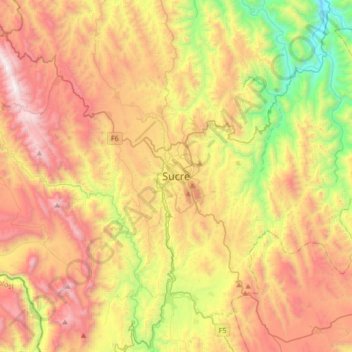
Name: Sucre topographic map, elevation, terrain.
Average elevation: 2,829 m
Minimum elevation: 1,882 m
Maximum elevation: 3,846 m
Sucre (Spanish: [ˈsukɾe]) is the capital of Bolivia, the capital of the Chuquisaca Department and the 6th most populated city in Bolivia. Located in the south-central part of the country, Sucre lies at an elevation of 2,810 m (9,220 ft). This relatively high altitude gives the city a subtropical highland climate with cool temperatures year-round.
Other topographic maps
Click on a map to view its topography, its elevation and its terrain.
Chaunaca
Bolivia > Chuquisaca > Provincia Oropeza > Municipio Sucre
Chaunaca, Municipio Sucre, Provincia Oropeza, Chuquisaca, Bolivia
Average elevation: 2,954 m
Sanabria
Bolivia > Chuquisaca > Provincia Oropeza > Municipio Poroma
Sanabria, Municipio Poroma, Provincia Oropeza, Chuquisaca, Bolivia
Average elevation: 2,965 m